Thursday, April 25, 2013
Monday, January 28, 2013
2007 San Diego Firestorm - Fire Boundaries
In 2007 there were multiple fires burning in the San Diego region. These fires caused a lot of confusion and fear, as well as being the reason for one of the largest evacuations ever in the state.
Below is a quick map of the various fires that burned in the region. Collectively these are known as the 2007 Firestorm.
View Larger Map
During the month of October, which most people think of as wet wintertime, we get seasonal santa ana winds in the region. These are dry, warm winds that blow from the east over the desert, instead of the prevailing winds from the west over the ocean. These winds, along with high heat and dry conditions, combine to create the worst time for potential fires in the region.
Tuesday, December 04, 2012
Wednesday, November 07, 2012
Showing someone the capabilities of embedding maps in web pages.
View Larger Map
Searched for data layer, added to map, changed symbology, modified pop-up, saved, shared. It's that easy!
Made web map in five minutes, posted to the web in one. Could also save to web application. And the web map will open up in any browser, on any device - even smart phones and tablets.
Learn more at http://www.arcgis.com/about/ or the product page at: http://www.esri.com/software/arcgis/arcgisonline
Monday, February 27, 2012
Free Hands-On Workshops – April 11th, Sacramento
Esri half-day workshops
Wednesday, April 11th from 8:30-12:00 or 1:30-5:00.
Esri Sacramento offices, 1600 K St, Suite 4C, Sacramento CA 95814-4022
Join us for a hands-on workshop where we’ll explore the latest enhancements to ArcGIS Online, Esri's cloud-based geospatial content management system for storing and sharing maps, data, and other related information. ArcGIS Online makes it possible to share your information through a series of rich maps and apps for desktop, web, and mobile use. Learn how you can create communities; share and discover geospatial information; and take advantage of new templates to create easy-to-use maps and applications. Hear about free basemaps, web viewers, hosted mapping services and how to extend the reach of your GIS throughout your organization.
To register for this free event, or for questions, please email Lorene Wilson at LWilson@esri.com
Wednesday, February 01, 2012
Imperial Beach, CA Schools
Thinking of moving to the San Diego region? Towards the south below San Diego Bay is the city of Imperial Beach. If you are looking for a quieter area, this might be the place. If you have kids you will be interested in the map below which shows the locations of all the schools in the city – Elementary through Adult.
View Larger Map
For more information on the city, visit their website at http://www.cityofib.com
View Larger Map
For more information on the city, visit their website at http://www.cityofib.com
Thursday, January 26, 2012
San Diego Fire – FY 2011 Incidents & Response Times
Here’s a quick web map I made from data available for the San Diego Apps Challenge. There is a ton a data available – especially spatial data – for the City of San Diego. This challenge is a great way to win a little cash and create some nice geospatial apps!
View Larger Map
Map built from CSV file on ArcGIS.com.
Thursday, November 17, 2011
Looking for a Park in the City of Poway?
There are quite a few parks within the City of Poway.
Here’s a map of them to aid you in locating where to go for a walk, or party, or dog walk, or whatever.
Want to make a map with your topic of interest on it, and use it in your web site? It’s easy!
Esri continues to update and expand ArcGIS.com with new features and functionality. Lots of great stuff there now, and more continues to be released every few months – you can do things like the embedded maps you see on this blog, and all for free!
A nice feature is drag & drop of CSV files to create “dots on a map” – this is how I got the Poway Parks on the map below. This functionality was recently upgraded to allow for your CSV file to be stored online in the location of your choosing – and when updates happen to that online file, they are reflected on your map without you having to reload & re-symbolize the data! Very nice.
When you are creating your map with the ArcGIS.com map viewer your searches will now be more relevant – it used to be that a search for “fire” brought back a LOT of layers to dig through, many from other states, or around the world. Interesting, but generally not very useful when building a map view focused on a single city. Well, the December 2011 ArcGIS Online update added Spatial Search. So now when I am zoomed into Poway and I search on “fire” – I get a much more relevant list of map services returned to me.
Also be sure to check out the bottom of that post because it has some information on ArcGIS Online subscriptions. More on this in the next few months,
Also remember that the maps you create and share with ArcGIS.com can be used in multiple ways. Below is an example of how easy it is to embed a map. But I could have also chosen to use this map as a web application. Check it out: http://bit.ly/vF0c2I
A new feature in a recent update was the ability to share a map, select one of the ArcGIS.com map app templates, and then actually publish that map into the ArcGIS Online cloud! This is fantastic for community groups or agencies that don’t have a public facing ArcGIS Server box, but want to be able to share information publically. More and more important these days for public agencies looking to increase transparency into their data and work. Feel free to ping me if you want to do this but aren’t sure where to go.
I highly recommend keeping an eye on the ArcGIS Online Blog – it is updated often with tips & tricks as well as announcement and descriptions on updates as they occur. There’s a lot to keep up with Enhanced HTML5 support, KML support, enhanced sharing, more symbols & symbol search, support for secure ArcGIS services (this is huge for many agencies),
View Larger Map
Have fun in Poway! Be sure to also visit the city web site.
Also – let me know about maps you are creating and embedding, or that you publish with an ArcGIS.com template. I’ll highlight it here on my blog!
Happy mapping!
Wednesday, November 16, 2011
City of Carlsbad Libraries
Here’s a quick example of a simple locations map showing the libraries in the City of Carlsbad.
And this blog post serves as an example of embedding a live map from ArcGIS Online into a web page, and I will also register this on ArcGIS.com as yet another example.
View Larger Map
The HTML code for this embedded map was auto-generated by ArcGIS.com in the map viewer, from the Share button. This is an example of the Large sized map with the zoom control included.
Check it out here: http://www.arcgis.com/home/item.html?id=fc2ef60171d441aab41886ba01172c23
Friday, November 04, 2011
Locations for Sandbag pickup in San Diego County
The County of San Diego is nice enough to provide free sandbags to folks that live in the unincorporated areas. Great on days like today when we get the first real rain of the season - or for people that still have fire scares on their property, etc.
The County website has additional information here: http://www.countynewscenter.com/news/county-giving-free-sand-bags-residents
Quickly you will see that there are seven locations. There are partial addresses and no map to help you get your bearings.
I decided to map it out. I did a little copy/paste work putting the location info into a CSV file. Loaded that up into ArcGIS Explorer Online to geocode the locations and do some editing of the icons and such. Dropped that into the ArcGIS.com Map Viewer and shared it out publicly, and also generated the HTML code to pop into this quick blog post.
Now I know where to go in Valley Center if I should need some sandbags!
View Larger Map
Hopefully I won't need them, but if I do...
Thursday, May 05, 2011
GIS Managers' Open Summit - Esri UC 2011
Did you attend the Esri User Conference (UC) last year? Did you make it to the GIS Managers' Open Summit? It was an interesting day, and our first time having an unconference as part of the UC. Most of the folks there were not really familiar with the idea of an unconference or how it works, but they all survived and I think most got a lot out of it.
At the end of the day I asked Victoria if she thought we would do this again next year. She didn't know, but hoped we would. I had to agree.
Well, here we are a year later. And guess what? Not only are we doing the Open Summit again - but we are doing it over two days! Tuesday and Wednesday, with a few twists to the schedule, and a few little changes from last year.
More to come on that. Watch for Tweets on the subject - specifically follow @geoTC and @VKouyoumjian for updates on Open Summit. Also follow @EsriUC for all things UC.
So plan on coming by for a day, or a morning, or an afternoon. We would love to see you there. If you would like to add it to your "My UC" agenda - here's the link: http://events.esri.com/uc/2011/infoweb/onlineagenda/?fa=ofg_details_form&ScheduleID=2096 for Tuesday. Then at the bottom for that page is the link for Wednesday.
You can also follow along and keep the conversation going on the LinkedIn 'Managers in GIS' group.
Look forward to seeing you there, hearing about your work, and discussing all things GIS in an unconferency way.
Tuesday, January 11, 2011
Metadata in ArcGIS 10
I have had some clients asking about the changes in the way Esri is handling Metadata in ArcGIS 10. If you missed the session at the 2010 User Conference then you will be extra interested in this new series of blog posts related to the topic.
A new approach to Metadata with ArcGIS 10 (part 1)
A new approach to Metadata with ArcGIS 10 (part 2)
Be sure to review the comments and replies as there is additional or updated information contained there.
More to come!
Wednesday, December 22, 2010
Developer Code Challenges – Light It Up!
Sent this note out to some clients, and thought others might be interested as well, so thought I’d share…
There are two developer coding contests happening that you may be interested in.
The “Flex-A-Widget Challenge” – build a widget for the Flex viewer, share it on ArcGIS.com and submit your entry. Winners announced at DevSummit.
http://www.esri.com/events/devsummit/get-involved/widget-challenge.html
And the “Light Up the Night Challenge” – happens at the DevSumit along with Microsoft developers. You will be given a challenge at the event – you code a solution.
The prizes for both are pretty sweet.
http://www.esri.com/events/devsummit/get-involved/lightup-challenge.html
---
OK – So I didn’t say “pretty sweet” in my email… =)
These look like some great opportunities to show off your programming skills!
Wednesday, December 08, 2010
Wednesday, September 08, 2010
Get rid of it!
Been seeing this abandoned truck on the side of the road for about 3 months. Doors off, a real mess – who knows how long it has been sitting there. Looked like a real long time.
I finally had a chance to pull over and make a CitySourced report about it on Sept 5th.
Here is my report with photo to CitySourced: http://www.citysourced.com/report/6906/abandoned-vehicle
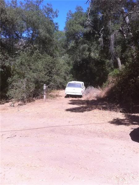 Abandoned Vehicle - Issue Reported in Valley Center, CA
Reported On: 09/05/2010 @ 03:04 PM
Reported By: Anonymous
Address: 29845-29999 Anthony Rd, Valley Center, CA 92082, USA
Latitude: 33.251583
Longitude: -117.050011
Direction: North
Description: Truck about 60 feet east of Anthony Road. Looks like it has been here a long time.
Device: Apple iPhone 4
Current Status: Submitted
I drove by the spot 2 days later and noticed that it was gone!
Was totally (happily) surprised to see it gone. Fantastic! I had hoped my report would lead to it being taken away, but didn’t think it would be so fast.
Take a look at CitySourced and help make your community a better place by reporting issues around your neighborhood: http://www.citysourced.com/
Happy CitySourcing!
Friday, July 16, 2010
Monday, July 12, 2010
Esri User Conference – UC 2010
The first day of the 30th annual Esri International User Conference is about 1/2 over now. It has been a great morning of user stories, product demos and vision discussion.
Keep up-to-date on all the happening on the Esri UC Insider page: http://blogs.esri.com/Info/blogs/ucinsider/default.aspx
Looks like they are doing a great job keeping this in sync with all the activities as they happen!
Watch all the action on Twitter for minute-to-minute updates! #EsriUC
Monday, June 07, 2010
WhereCamp SoCal is on! July 17/18 2010
In case you missed the multiple Tweets and a few blogs posts about it today, the WhereCamp SoCal event is now set for date and location:
July 17 & 18, 2010 (this is the Sat/Sun) directly after the ESRI User Conference at San Diego State University (SDSU) in the Adams Humanities building. Specific details to come. This is right next to the San Diego Trolley so use public transportation when you can.
Check out the official site for updates: http://www.wherecampsocal.org/
We are still taking sponsors if your company might be interested – let us know at info@wherecampsocal.org or join the Google Group and add to the conversation: http://groups.google.com/group/wherecamp-socal. You can also follow on Twitter @WhereCampSoCal
Keep an eye on the blog for quick updates if Twitter isn’t your thing: http://blog.wherecampsocal.org/
Hope to see you there!
Thursday, April 22, 2010
WhereCamp SoCal – where? when?
You may have heard Twitter (@ortelius / @geoTC / @wherecampsocal) about a Geo WhereCamp in the southern California area. Well, you heard right.
Debate is still open about date & location. We are going to pick a location and date soon – so if you have any input let us know now. Pop us a Tweet at @geoTC & @ortelius with your ideas!!
Subscribe to:
Posts (Atom)

