A collection of various GIS related links, information and other GIS blogs.

Showing posts with label Mobile. Show all posts

Wednesday, September 08, 2010

Get rid of it!

Been seeing this abandoned truck on the side of the road for about 3 months. Doors off, a real mess – who knows how long it has been sitting there. Looked like a real long time.

I finally had a chance to pull over and make a CitySourced report about it on Sept 5th.

Here is my report with photo to CitySourced: http://www.citysourced.com/report/6906/abandoned-vehicle 

Abandoned Vehicle - Issue Reported in Valley Center, CA 
Reported On: 09/05/2010 @ 03:04 PM
Reported By: Anonymous
Address: 29845-29999 Anthony Rd, Valley Center, CA 92082, USA
Latitude: 33.251583
Longitude: -117.050011
Direction: North
Description: Truck about 60 feet east of Anthony Road. Looks like it has been here a long time.
Device: Apple iPhone 4
Current Status: Submitted


I drove by the spot 2 days later and noticed that it was gone!

Was totally (happily) surprised to see it gone. Fantastic! I had hoped my report would lead to it being taken away, but didn’t think it would be so fast.

Take a look at CitySourced and help make your community a better place by reporting issues around your neighborhood: http://www.citysourced.com/ 

Happy CitySourcing!

Tuesday, May 19, 2009

Tweet Tweet

Been using Twitter now for a few months. “Micro-Blogging” yet so very different from a blog. Been through a few desktop applications to better my Twitter experience, but was still using http://twitter.com when out and about on my Windows Mobile device. I knew there had to be something better.

Where to turn? To Twitter of course! I had seen folks Tweeting about different applications for the Blackberry – then did see a series of Tweets about Windows Mobile – this is where I learned about Twikini.

So I grabbed the beta and liked it right away. Easy to use, and code updates often with new features. I’m really liking it. Be sure to check out the menus as there are lots of features in there. Also see the main features here.

You can even add your location information to your Tweets:

image

If you are on Twitter and have a Windows Mobile device, I recommend that you take a look at Twikini. Oh ya – if you are interested in following me, I am @Tim_Craig

Friday, September 19, 2008

ArcGIS Mobile Blog : Oakland County Animal Control


Oakland County Animal Control

At the Mobile and LBS Special Interest Group meeting held Wednesday evening, Mike Dagle and Scott Oppmann from Oakland County Michigan shared their experiences deploying a solution for Oakland County Animal Control using ArcGIS Server and the newly released ArcGIS Mobile application.

Dagle Presentation
Mike Dagle discussing implementation lessons learned

Background
Oakland County Animal Control was established in 1919 to enforce pet-ownership laws and control stray pet population. Each year Animal Control conducts a dog census. The goal of the census is to both estimate the number of domestic pets and locate/issue citations any unlicensed dogs. Due to the size of county, approximately 10 municipalities are canvassed each year and the County uses summer students to conduct the census.

Prior to implementing ArcGIS Mobile, the process involved geocoding current dog licenses, joining the geocoded location to tax parcels, creating a series of 11x17 paper maps, conducting the census on paper log sheets and then manually entering the logged results into a database in the office. There were several limitations with their current process that by implementing ArcGIS Mobile they hoped to overcome - needless production of many paper maps, redundant entry of information, potential error/loss of data by poorly written/lost/damaged logs, inefficient use of staff with considerable lag time between field logging and data entry.

Solution
Mike Dagle, Scott Oppmann, Dawn Beemer and Brian Ely from the County chose to use ArcGIS Server and deploy the new ArcGIS Mobile application to census takers. They were able to leverage their existing investment in ArcGIS. They replicated their Tax Parcels geodatabase and transformed the parcels feature class to include Animal Census attributes. Then using ArcMap, they symbolized the parcels layer to create a unique list of feature types that would represent the target properties for census takers.

Map Symbolization
Unique value rendering in ArcMap and ArcGIS Mobile

Once the map and geodatabase were in place, the next step was then to simply publish the map as a map service with mobile data access capabilities in ArcCatalog and then use the ArcGIS Server Manager application to author the Animal Control project for field use with the ArcGIS Mobile application. A Windows 2003 Server box running IIS 6...follow link below for the rest of the story...

ArcGIS Mobile Blog : Oakland County Animal Control

Tuesday, August 26, 2008

ArcGIS Mobile Blog : New Community Center for ArcGIS Mobile!


New Community Center for ArcGIS Mobile!

The ArcGIS Mobile Resource Center introduced a new Community Center today!

The goal of the Community Center is to grow a vibrant online community centered around Mobile GIS. The community center aggregates all sources of information that change frequently so you have the most recent information. It includes this blog site, forums, knowledge base articles, and a code gallery for developers.

With the launch of the community center, the mobile dev team has uploaded a number of code samples that you can download in the code gallery. All samples uploaded by the dev team are clearly indicated by the "ArcGIS Mobile Development Team" tag on the sample.

During our presentations at UC2008 (both in the technical workshops and at the Mobile Island Demo Theatre), we wrote a lot of code and those of you who attended our presentations have asked for us to share it with you. So the code samples prefixed with "ArcGIS Mobile - " are exactly those samples. Once you have taken a look, please come back to the code gallery and give these samples a rating!

To post your code to the code gallery, all you need to do is log into the code gallery using your ESRI Global account. If you do not yet have one, you can sign up for one here.

...Follow the link below to view the full posting...

ArcGIS Mobile Blog : New Community Center for ArcGIS Mobile!

Friday, August 22, 2008

ArcGIS Mobile Blog : Reflecting on UC 2008

[ I get this question a lot - which technology do I need, ArcPad or ArcGIS Mobile?  This post from the ArcGIS Mobile blog discusses this very topic! ]

Reflecting on UC 2008

The users conference has come and gone and we are very thankful to all that came to our technical sessions, demo theatre presentations, and engaged us in conversation at the Mobile Island. This year was a big success for ArcGIS Mobile and we are now back into Redlands busy planning our next release. We received a lot of wonderful feedback from you and are integrating that feedback into our planning and future development as I write this.

We will begin a series of posts on this blog site that provide detailed answers to the most frequently asked questions we received at the island and in our sessions. Here is a sample:

What is the difference between ArcPad and ArcGIS Mobile? How do I choose between the two of them?

ArcPad and ArcGIS Mobile are separate technologies designed for mobile GIS. When deciding which is the appropriate solution to deploy, you need to consider what your field GIS project needs are, the number of field workers you need to deploy Mobile GIS to, and how Mobile GIS fits into your existing IT infrastructure. Follow the link below for the rest of the post...

ArcGIS Mobile Blog : Reflecting on UC 2008

Wednesday, June 04, 2008

City of Dover, Delaware, Deploys Groundbreaking GIS Application for NASCAR Events

ArcWatch, May 2008

ArcGIS Server and ArcGIS Mobile Help Officials Monitor Events and Respond Faster to Emergencies

City of Dover, Delaware, Deploys Groundbreaking GIS Application for NASCAR Events

By Jesse Theodore, ESRI Writer

click to enlarge
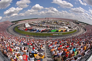
NASCAR fans gather for the races at the Dover International Speedway in Dover, Delaware. Photograph by Reinhold Matay.

The weekend of May 30–June 1, more than 140,000 fans will line "The Monster Mile" in Dover, Delaware, to whistle and cheer as they urge on their favorite drivers during three days of NASCAR races.

But while others focus on cars traveling at speeds up to 150 miles per hour around the track at Dover International Speedway, public safety officials will be busy watching for problems and ensuring a safe, secure event. And as medical emergencies, disturbances, and code violations are reported, officials will rely on geographic information system (GIS) technology to help them respond to, manage, and coordinate activities faster than ever before.

Managing a City of Race Fans

One of the toughest tasks for local government agencies is managing large-scale events. The City of Dover (population 35,000) has a particularly unusual public safety issue. Twice a year, the city hosts major NASCAR races. The city's population swells to more than 200,000 as fans from all over the United States descend on Dover.

This creates an enormous challenge as local government officials work to protect the many temporary residents visiting the area. Staff and resources come from the fire, health, emergency medical services, law enforcement, public works, and utilities departments and agencies.

click to enlarge
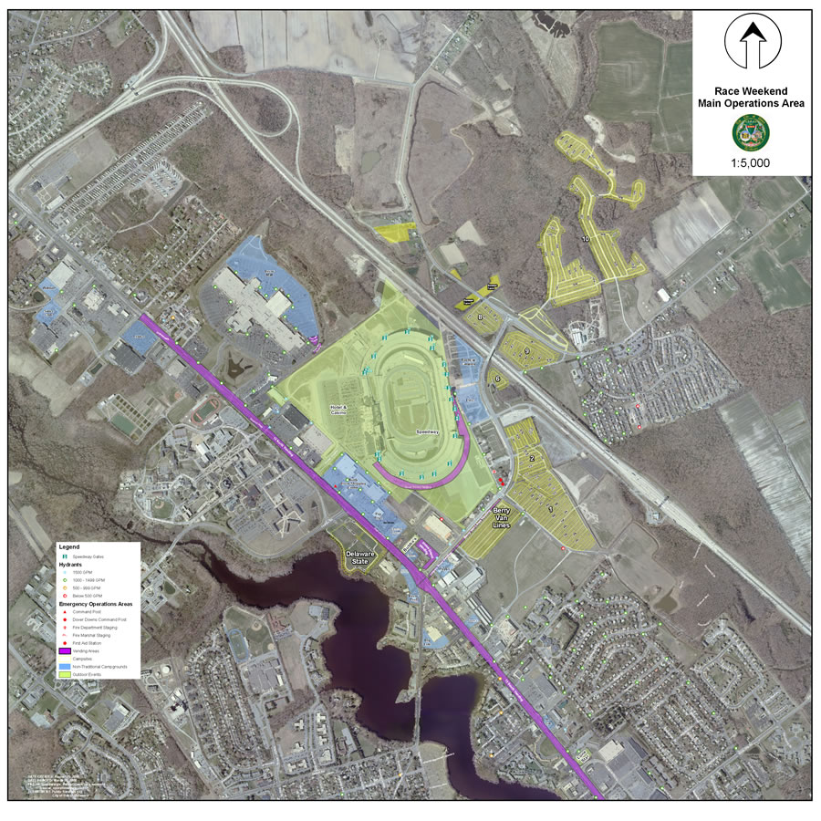
A map of the overall operational area with a 2007 aerial photograph.

To help coordinate every aspect of this vast operation, the City of Dover recently deployed an advanced enterprise GIS platform that gives venue managers the ability to access data and visualize what's happening where at Dover International Speedway. GIS also lets them capture, integrate, and analyze important public safety data, which helps them respond faster and more efficiently to emergencies or other problems. The enterprise solution was successfully used during the NASCAR races that the speedway hosted in June and September 2007.

GIS technology allows event managers, stationed in the Kent County, Delaware, mobile command center next door to the speedway, to view digital map displays of the entire race venue including the track. On the digital maps, the managers receive information concerning incidents and crowd activity.

Using ArcGIS Server and ArcGIS Mobile software from ESRI, staff operating in the command center and in the field can visualize where disturbances, code violations, accidents, and other incidents occur.

Read the full article:  ESRI ArcWatch May 2008 - City of Dover, Delaware, Deploys Groundbreaking GIS Application for NASCAR Events

Friday, January 04, 2008

ArcPad 7.1 Now Available

ArcPad 7.1 and ArcPad Application Builder 7.1, the latest versions of ESRI's mobile GIS software for data collection and field mapping applications, are now available. New features and capabilities in ArcPad 7.1 increase mobile productivity by providing field-based personnel with the ability to capture, store, update, and analyze geographic information more accurately and efficiently. ArcPad easily integrates with desktop and server GIS technologies, allowing field edits to be incorporated into a geodatabase through disconnected editing. Data input from GPS receivers, range finders, and digital cameras is also supported to increase reliability in the field data collection process. ArcPad 7.1 introduces a much-anticipated, out-of-the-box solution to view and edit features and related tables in the field. The ArcPad Data Manager extension for ArcGIS Desktop makes it easier to manage mobile GIS project deployments. In addition, a new StreetMap extension is included in ArcPad 7.1 at no additional cost. Read More... Download an evaluation copy