A collection of various GIS related links, information and other GIS blogs.

Wednesday, December 22, 2010

Developer Code Challenges – Light It Up!

Sent this note out to some clients, and thought others might be interested as well, so thought I’d share…

There are two developer coding contests happening that you may be interested in.

The “Flex-A-Widget Challenge” – build a widget for the Flex viewer, share it on ArcGIS.com and submit your entry. Winners announced at DevSummit.

http://www.esri.com/events/devsummit/get-involved/widget-challenge.html

And the “Light Up the Night Challenge” – happens at the DevSumit along with Microsoft developers. You will be given a challenge at the event – you code a solution.

The prizes for both are pretty sweet.

http://www.esri.com/events/devsummit/get-involved/lightup-challenge.html

---

OK – So I didn’t say “pretty sweet” in my email…  =)

These look like some great opportunities to show off your programming skills!

Wednesday, September 08, 2010

Get rid of it!

Been seeing this abandoned truck on the side of the road for about 3 months. Doors off, a real mess – who knows how long it has been sitting there. Looked like a real long time.

I finally had a chance to pull over and make a CitySourced report about it on Sept 5th.

Here is my report with photo to CitySourced: http://www.citysourced.com/report/6906/abandoned-vehicle 

Abandoned Vehicle - Issue Reported in Valley Center, CA 
Reported On: 09/05/2010 @ 03:04 PM
Reported By: Anonymous
Address: 29845-29999 Anthony Rd, Valley Center, CA 92082, USA
Latitude: 33.251583
Longitude: -117.050011
Direction: North
Description: Truck about 60 feet east of Anthony Road. Looks like it has been here a long time.
Device: Apple iPhone 4
Current Status: Submitted


I drove by the spot 2 days later and noticed that it was gone!

Was totally (happily) surprised to see it gone. Fantastic! I had hoped my report would lead to it being taken away, but didn’t think it would be so fast.

Take a look at CitySourced and help make your community a better place by reporting issues around your neighborhood: http://www.citysourced.com/ 

Happy CitySourcing!

Friday, July 16, 2010

Monday, July 12, 2010

Esri User Conference – UC 2010

The first day of the 30th annual Esri International User Conference is about 1/2 over now. It has been a great morning of user stories, product demos and vision discussion.

Keep up-to-date on all the happening on the Esri UC Insider page: http://blogs.esri.com/Info/blogs/ucinsider/default.aspx 

Looks like they are doing a great job keeping this in sync with all the activities as they happen!

Watch all the action on Twitter for minute-to-minute updates! #EsriUC

Monday, June 07, 2010

WhereCamp SoCal is on! July 17/18 2010

In case you missed the multiple Tweets and a few blogs posts about it today, the WhereCamp SoCal event is now set for date and location:

July 17 & 18, 2010 (this is the Sat/Sun) directly after the ESRI User Conference at San Diego State University (SDSU) in the Adams Humanities building. Specific details to come. This is right next to the San Diego Trolley so use public transportation when you can.

Check out the official site for updates: http://www.wherecampsocal.org/ 

We are still taking sponsors if your company might be interested – let us know at info@wherecampsocal.org or join the Google Group and add to the conversation: http://groups.google.com/group/wherecamp-socal. You can also follow on Twitter @WhereCampSoCal

Keep an eye on the blog for quick updates if Twitter isn’t your thing: http://blog.wherecampsocal.org/ 

Hope to see you there!

Thursday, April 22, 2010

WhereCamp SoCal – where? when?

You may have heard Twitter (@ortelius / @geoTC / @wherecampsocal) about a Geo WhereCamp in the southern California area. Well, you heard right.

Debate is still open about date & location. We are going to pick a location and date soon – so if you have any input let us know now. Pop us a Tweet at @geoTC & @ortelius with your ideas!!

Monday, March 22, 2010

Some ArcGIS 10 Tips from Crystal Dorn

Not everyone gets to spend time in Palm Springs at the ESRI Developer Summit (on Twitter @ESRIDevSummit and follow Hashtag #devsummit). Included in that group with you and me is Crystal Dorn from the CA/HI/NV Regional Office (on Twitter @CrystalDorn).

One thing we have seen year after year is that clients love to see Crystal’s Usability Tips & Tricks demos at meetings and conferences. So when she told me she was going to Tweet some tips from ArcGIS 10 (#ArcGIS10) I decided that I would RT them out as well. And for you folks not on Twitter for whatever reason, I thought it might be nice to gather them all up in one blog post too! So here you go…

@CrystalDorn: Love it! Searching for symbols super easy & faster, e.g. "Hazmat RED" lists all hazmat red symbols! #ArcGIS10 

@CrystalDorn: Select by Lasso on the new Selection Tools where have you been my whole ArcMap life? Sometimes it's the little things! #ArcGIS10

@CrystalDorn: ArcMap Table container window lets attribute table be docked side-by-side or opened via tabs - great feature! #ArcGIS10

@CrystalDorn: Woohoo can change edit sketch (vertex, segments, etc.) symbology now in Editor options! #ArcGIS10 

@CrystalDorn: ...and can select multiple vertices! New Edit Vertices toolbar will be a popular feature of #ArcGIS10 

I think Crystal is on the road tomorrow, so probably no new tips. I’ll keep an eye out though, and if she starts up again I will RT and post them here.

Thursday, January 21, 2010

ESRI Tools & Resources for Haiti (& other) Response Efforts

Updated: Jan 21, 2010:

TwitterSearch Flex viewer Widget: http://resources.esri.com/arcgisserver/apis/flex/index.cfm?fa=codeGalleryDetails&scriptID=16782 
The idea for this widget came about at the Random Hacks of Kindness event in CA back in Nov 2009. The BarCamp discussions had a lot of talk about crowd-sourced information, especially Tweets. We weren’t able to complete the code for this widget at the event, but now it is ready for prime time (well, beta prime time). It is a multi-fuction widget in that you can search for Tweets within a draw radius area (like around the island of Haiti), and you can also filter your radius search results by up-to three keywords or hashtags. This widget also allows you to send Tweets, and even better – geo-locate those Tweets. So if you are Tweeting about something happening somewhere else, you can locate the Tweet in that area. Widget is also ready to go in the GEO Viewer. Thanks Andy!

Updated Imagery available via ArcGIS Online:
NOAA imagery (Jan 20): http://www.arcgisonline.com/home/item.html?id=2c570d9fcda24f4085e55bd8d8f1eeda 
Bing Maps, Digital Globe imagery (Jan 18): http://www.arcgisonline.com/home/item.html?id=6e4d40bc81dd4e70b265a4aa22961a79


Updated: Jan 20, 2010:

Accessing OpenStreetMap data within ArcGIS to support the Haiti Earthquake Response: http://blogs.esri.com/Dev/blogs/publicsafety/archive/2010/01/20/Accessing-OpenStreetMap-data-within-ArcGIS-to-support-the-Haiti-Earthquake-Response.aspx 
This post on the ESRI Public Safety blog discusses how you can use OpenStreetMap data in ArcGIS Desktop. With all the work being done on updating these data post-earthquake, this is useful information.

Free Flex Sample viewer: http://resources.esri.com/arcgisserver/apis/flex/index.cfm?fa=codeGalleryDetails&scriptID=15905 
This sample viewer allows you to build a website without needing ArcGIS Server. It hits freely available ArcGIS Online data and allows for some viewer customization via configuration files, so no need to compile code. You can also deploy some of the free widgets available from the Resources pages. Some examples of widgets you may like to include are:
- Twitter Geospatial Search Widget (draw a radius on the map to retrieve geo-located Tweets within that area): http://resources.esri.com/arcgisserver/apis/flex/index.cfm?fa=codeGalleryDetails&scriptID=16448 
- Google Streetview Integrated with AGS Flex API (click on the map to grab Google Streetview at that location): http://resources.esri.com/arcgisserver/apis/flex/index.cfm?fa=codeGalleryDetails&scriptID=16070 

GeoEye Image Service published in the Amazon Cloud: http://events.arcgisonline.com/ArcGIS/rest/services/GeoEye_Haiti_Jan13/ImageServer 
More services: http://events.arcgisonline.com/ArcGIS/rest/services 
January 13 GeoEye imagery as an Image Service for REST, SOAP or WMS access

Tools available from ArcScripts for working with OpenStreetmap data: http://arcscripts.esri.com/scripts.asp?eLang=&eProd=&perPage=10&eQuery=openstreetmap 
Query on ArcScripts for OSM related entries.

Free tools and widgets available for your mapping websites:
- Flex:
http://resources.esri.com/arcgisserver/apis/flex/index.cfm?fa=codeGallery 
- Silverlight:
http://resources.esri.com/arcgisserver/apis/silverlight/index.cfm?fa=codeGallery 
- JavaScript:
http://resources.esri.com/arcgisserver/apis/javascript/arcgis/index.cfm?fa=codeGallery 
- .NET:
http://resources.esri.com/arcgisserver/adf/dotnet/index.cfm?fa=codeGallery 
- Java:
http://resources.esri.com/arcgisserver/adf/java/index.cfm?fa=codeGallery 
These are all part of the user communities for each product. ESRI supports and encourages the sharing of code through these community pages.


Original Post Jan 15, 2010:

Geo Status Widget for Flex Viewer: http://resources.esri.com/arcgisserver/apis/flex/index.cfm?fa=codeGalleryDetails&scriptID=16686
This widget allows you to geo-locate a Tweet. So if you want to reference a Tweet to an event or location without being there, this is one way to do that via clicking on a map to select the location. This widget was developed onsite at the Random Hacks of Kindness event Nov 2009.

ArcGIS Online Haiti Earthquake: http://www.arcgisonline.com/home/group.html?owner=esri_event&title=Haiti%20Earthquake
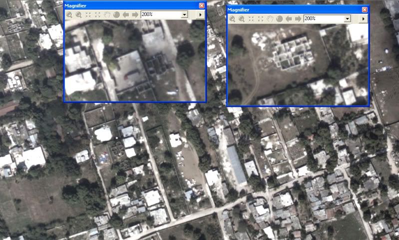
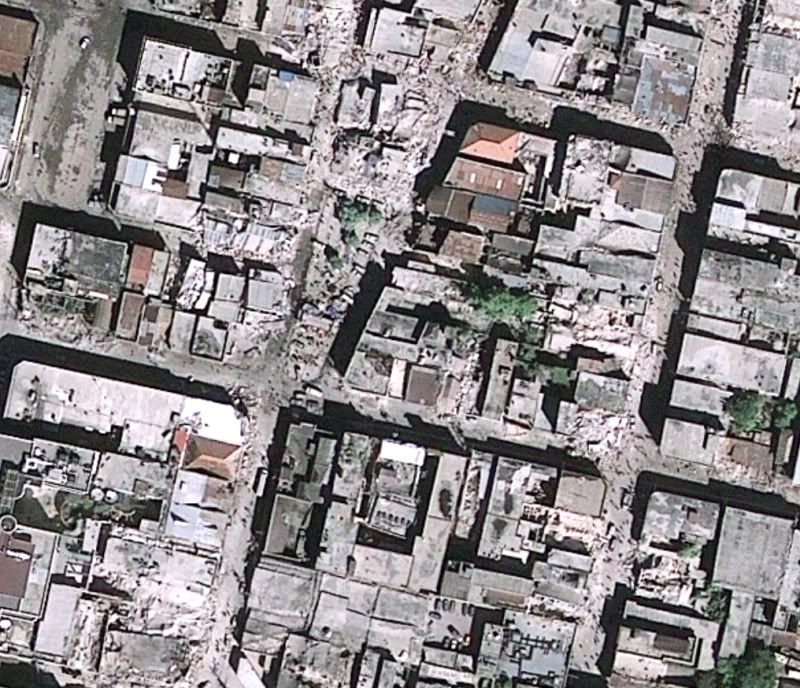
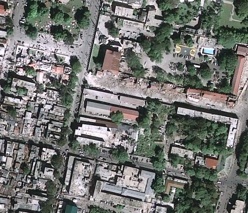
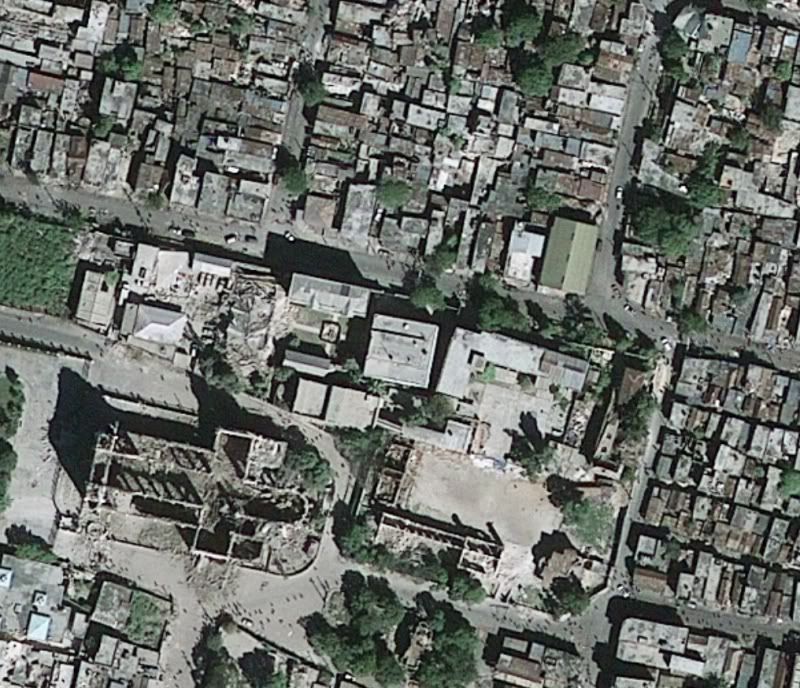
Free data and information related to Haiti and earthquake including post-event imagery from GeoEye (as a layer, in a map document, or as a web app for data download – see samples of imagery below). Click on the Content tab to see what is available. Update 1-20-10: Data are continually being added here. When I first made this post there were 7 items, today there are 24 – keep it coming!

Add Additional Data to ArcGIS Online: http://blogs.esri.com/Support/blogs/arcgisonline/archive/2010/01/15/adding-content-to-arcgis-online.aspx 
So you have access to some data or maps related to the Haiti Quake and are wondering how you can share it? The post linked above steps you through the process with ArcGIS Online.

Geoss Viewer: http://geoss.esri.com/geoviewer/
Follow Tweets within a drawn radius area, display geoRSS feeds from USGS and other groups, compute population within drawn area, and more.

Disaster Response and Assistance: http://www.esri.com/services/disaster-response/earthquakes/index.html 
Free temporary software, data, imagery technical support and other resources to help people supporting the disaster response and recovery efforts in Haiti.

Web APIs free for non-commercial use: http://resources.esri.com/arcgisserver/index.cfm?fa=applications 
These web API’s allow you to pull data from the Cloud and mash it up with other sources of data. Pick your flavor – Flex, Silverlight, JaveScript, .NET, or Java.

ArcGIS Online data for Desktop use or Web use – no cost for non-commercial use (Standard services): http://www.esri.com/software/arcgis/arcgisonline/map-services.html 
Imagery, streets, political, etc – global data

World Geocoding and World Routing available as Task Services – no-cost for non-commercial use: http://www.esri.com/software/arcgis/arcgisonline/task-services.html 
Use in ArcGIS Desktop or free web mapping APIs


Sample images from GeoEye imagery of Haiti, post Jan 2010 earthquake (click for larger image)

Monday, January 11, 2010

This One’s a 10

ESRI made an announcement late today, and word has spread fast. 9.4 has been renamed to be version 10.

Here is the official announcement as a podcast from Jack, where he describes why this decision was made and he discusses some of the features included in 10 and why it justified a full version number. http://www.esri.com/news/podcasts/audio/speaker/dangermond_arcgis10.mp3 

Listen to the podcast, and also view the What’s Coming page for ArcGIS 10: http://www.esri.com/software/arcgis/whats-new/whats-coming.html 

From the traffic I’ve seen on Twitter a number of folks have blogged on this topic already, and it seems that no one is shocked or too questioning this version number change. Lots of good stuff in version 10.

The beta program is still open – talk to your ESRI representative for more information.

Some other blogs posts to review (I’m sure there will be many more tomorrow):

http://blog.gisuser.com/?p=5891&utm_source=twitterfeed&utm_medium=twitter 

http://www.spatiallyadjusted.com/2010/01/11/arcgis-9-4-is-now-arcgis-10/ 

http://geo.geek.nz/esri/arcgis-9-4-renamed-arcgis-10/