ArcWatch, May 2008
ArcGIS Server and ArcGIS Mobile Help Officials Monitor Events and Respond Faster to Emergencies
City of Dover, Delaware, Deploys Groundbreaking GIS Application for NASCAR Events
By Jesse Theodore, ESRI Writer

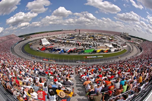
NASCAR fans gather for the races at the Dover International Speedway in Dover, Delaware. Photograph by Reinhold Matay.The weekend of May 30–June 1, more than 140,000 fans will line "The Monster Mile" in Dover, Delaware, to whistle and cheer as they urge on their favorite drivers during three days of NASCAR races.
But while others focus on cars traveling at speeds up to 150 miles per hour around the track at Dover International Speedway, public safety officials will be busy watching for problems and ensuring a safe, secure event. And as medical emergencies, disturbances, and code violations are reported, officials will rely on geographic information system (GIS) technology to help them respond to, manage, and coordinate activities faster than ever before.
Managing a City of Race Fans
One of the toughest tasks for local government agencies is managing large-scale events. The City of Dover (population 35,000) has a particularly unusual public safety issue. Twice a year, the city hosts major NASCAR races. The city's population swells to more than 200,000 as fans from all over the United States descend on Dover.
This creates an enormous challenge as local government officials work to protect the many temporary residents visiting the area. Staff and resources come from the fire, health, emergency medical services, law enforcement, public works, and utilities departments and agencies.

A map of the overall operational area with a 2007 aerial photograph.To help coordinate every aspect of this vast operation, the City of Dover recently deployed an advanced enterprise GIS platform that gives venue managers the ability to access data and visualize what's happening where at Dover International Speedway. GIS also lets them capture, integrate, and analyze important public safety data, which helps them respond faster and more efficiently to emergencies or other problems. The enterprise solution was successfully used during the NASCAR races that the speedway hosted in June and September 2007.
GIS technology allows event managers, stationed in the Kent County, Delaware, mobile command center next door to the speedway, to view digital map displays of the entire race venue including the track. On the digital maps, the managers receive information concerning incidents and crowd activity.
Using ArcGIS Server and ArcGIS Mobile software from ESRI, staff operating in the command center and in the field can visualize where disturbances, code violations, accidents, and other incidents occur.
Read the full article: ESRI ArcWatch May 2008 - City of Dover, Delaware, Deploys Groundbreaking GIS Application for NASCAR Events


1 comment:
Excellent project. Very impressive.
Post a Comment