Monday, March 05, 2007


Friday, February 23, 2007
Web-based Help Gateway - ESRI Support:
"Web-based Help Overview
ESRI provides Web-based help systems for the products listed below. Web-based help is an up-to-date version of the help system that was shipped with the product; new information has been added and existing topics have been updated as necessary. If you can't find what you're looking for in the help system that shipped with your product, try looking here."
This is your one stop for access to web-help for ArcGIS Desktop (9.1 and 9.2), ArcGIS Explorer, ArcGIS Server, ArcIMS and ArcWeb Services.
Wednesday, February 07, 2007
Earthwatch and Starbucks Benefit Coffee Farmers in Costa Rica:
-- and use GIS to help do it!
Newswise — Earthwatch Institute, the world’s leading environmental volunteer organization, and Starbucks Coffee Company are proud to announce the extension of their partnership that brings Starbucks partners (employees) and customers together on Earthwatch environmental expeditions. The 2007 project will focus on conducting scientific research designed to benefit a cooperative of 2,600 coffee farms in Costa Rica.
Partners and customers with a taste for adventure can participate in this different kind of Starbucks Experience, at the source of the bean, and do good deeds for the environment.
This summer, eight partners and 20 customers will have a chance to join special Earthwatch expeditions at CoopeTarrazú, a coffee cooperative in central Costa Rica. These Earthwatch volunteer teams will use GIS (Geographic Information System) technology to provide a broad scale analysis of factors important to a farmer – including soil erosion and water quality. This program is the first component of Starbucks’ $1.1 million, three-year commitment, representing the growing partnership with the Earthwatch Institute that began in 2000.
Sunday, February 04, 2007
ArcGIS Online - free base data, anywhere in the world!
Don't have some base data? Just starting your GIS and only have a few layers? Working on a project outside of your regular area? For these and many other reasons you should be interested in ArcGIS Online.
These are high-performance 2D and 3D web services and layerfiles for direct access by ArcMap, ArcGIS Explorer, ArcGlobe, ArcReader or ArcCatalog.
These data services will continue to be enhanced and will be updated as new data become available - so you no longer have to worry about keeping your base data up to date!
Monday, January 29, 2007
Events - 2007 ESRI Developer Summit:
ArcGIS Server Code Challenge
Share your creativity and expertise with the GIS developer community by submitting your original code sample to the ArcGIS Server Code Challenge.
Submit an original ArcGIS Server 9.2 code sample that represents a best practice or creative solution of a simple task, tool, or spatial query fromQuick Links your current project.
Custom ArcGIS Explorer Tasks qualify if they are associated with an ArcGIS Server 9.2 solution.
Entries will be judged by the developer community based on creativity, applicability, and originality of the code sample.
The first 15 applicants to submit their code samples and submission forms will be eligible to receive the book Agile Development with ICONIX Process: People, Process, and Pragmatism.
Official Rules
Prizes
Prizes will be awarded as follows:
First Place—one Trimble Recon® GPS XB Edition bundled with ArcPad software
Second Place—one Microsoft Xbox 360™
Third Place—one Microsoft Zune™"
Saturday, January 06, 2007
ArcGIS Desktop 9.2 Functionality Matrix - White Paper: "Summary:
This brochure compares the benefits of ArcReader, ArcView, ArcEditor, and ArcInfo. It folds out into a poster."
What's New in ArcGIS Desktop 9.2 - White Paper: "Summary:
This brochure offers a brief overview of 9.2 extension updates, new tools, and enhancements."
ArcGIS Server 9.2 - Help for .NET and Java - Your most up-to-date place to access Help for ArcGIS Server.
Friday, December 08, 2006
ArcGIS Server Development Blog
Here is a technical blog focused on ArcGIS Server - with posts written by the ArcGIS Server development team.
Enjoy!
Police connected through a new computer system:
"Police connected through a new computer system
DARCIE FLANSBURG, Staff Writer
Article Launched:12/06/2006 02:52:13 PM PST
After 20 years of using the same computer system, the Redlands Police Department has upgraded. According to Kurt Smith, Redlands police community analysis and technology director, there was a clear need to update the system.
The Sanders Software Computer-Aided Dispatch and Records Management System was state of the art in the 1980s when the department first used it, but is now out of date, said Redlands Police Chief Jim Bueermann.
The department began the evaluation process for a new system one year ago. In March 2006, the department sought City Council approval of a contract with Spillman Technologies Inc., an organization whose system was ESRI compatible as the department required. "
[ Kurt is a great guy that used to work in San Diego - but Redlands stole him away! ]
Saturday, November 04, 2006
The ArcPad Team Blog: "The ArcPad Team Blog
Unofficial stuff from the team behind the World's leading mobile GIS
Are you an ArcPad user? Then you might find this "unoffical" site interesting for it's tips and tricks and pointers on little known ArcPad features"
Monday, October 30, 2006
What's Coming in ArcGIS 9.2: "With ArcGIS 9.2, ESRI continues to focus on quality, usability, and performance.
ArcGIS Desktop (ArcView, ArcEditor, ArcInfo)
Check out the Usability Enhancements videos"
Project Center - ESRI Support: "Welcome to Project Center...
The Project Center provides an information portal to a wide range of GIS information, resources, and ESRI services for planning, designing, implementing and maintaining a successful GIS project lifecycle. The ESRI Project Center framework has been established so that you may quickly find available resources and services to support your specific GIS needs."
Maps for Journalists - Disaster Response and Assistance: "Riverside County Wildfire Maps and Images
Sunday, October 29, 2006
ESRI is supporting the firefighting efforts for the Esperanza Fire by providing GIS maps personnel on-site at the fire Incident Command Posts. Maps are provided as a public service to inform residents and other interested people."
Tuesday, October 03, 2006
Not GIS related - but cool....
Oxygen masks for dogs, cats donated to San Diego Fire Department: "Oxygen masks for dogs, cats donated to San Diego Fire Department
October 3, 2006
SAN DIEGO – Pets are ten times more likely to die in a fire than people and they are just as likely to suffer smoke inhalation, but now San Diego firefighters have devices designed to save the lives of four-legged victims.
Best Friends Pet Care, a national chain of boarding kennels, on Tuesday donated 20 sets of oxygen masks for animals to the San Diego Fire Department.
Each cone-shaped resuscitation mask fits tightly over a pet's snout and attaches to a tube that connects to an oxygen tank. They come in three sizes, one for large dogs, one for small dogs and one for cats.
Dawn Garcia, a manager at a local Best Friends facility, said that last year some 40,000 pets died in fires at homes across the nation. She animals are at a greater risk for smoke inhalation because they often don't find their way out.
“They don't know what to do, they run and hide,” Garcia said.
Deputy Fire Chief Jeff Carle said regular oxygen masks are ineffective for pets because they do not fit properly over an animals' face.
He said firefighters recently pulled six cats out of a burning apartment and two were suffering after inhaling smoke. They were able to save the felines by using the equipment on hand, but Carle said the new masks would have worked much better.
Best Friends launched the Cause for Paws Campaign nationally in 2004 and has since donated 2,250 sets of masks to fire departments in 20 states.
“We learned our rescue teams in our own back yard didn't have these masks and we wanted to help,” Garcia said.
Today's donation will provide the gear for go to less than half of the city's 46 fire stations. Garcia said Best Friends' goal is to equip all of them."
Friday, August 25, 2006
It was a LONG week at Strong Angel III (http://www.strongangel3.net). It is demonstration events like this that remind you just how important having maps is. Everyone, rightly so, wants to get their data and analysis on a map so that people know where things are happening - and what they are near.
And paper - digital mapping is great, but in crunch time the good ole paper map is still very much needed. The whole group was very happy to see ESRI roll in 2 huge HP 4000ps large-format printers on the second day. We became very popular as everyone needed to print, but no one had a printer.
And, as always, the Touch Table with ArcGlobe drew a crowd. It got a workout.
I thought I'd place links to stories and blog entries about the event here. Enjoy......
http://iht.com/articles/2006/08/28/business/disaster.php (8/28/06)
http://picasaweb.google.com/sanjanah/StrongAngelIII (Photos someone took)
http://blogs.zdnet.com/BTL/?p=3545 (8/25/06)
http://www.freerepublic.com/focus/f-news/1690083/posts (8/25/06)
http://www.signonsandiego.com/uniontrib/20060823/
news_1m23terror.html (8/23/06)
http://www.informationweek.com/security/showArticle.jhtml?articleID=192202134 (8/21/06)
http://www.govtech.net/magazine/channel_story.php/100561 (8/14/06)
http://www.spadac.com/ (These guys do some really interesting spatial analysis - we talked and worked with them a lot this last week)
http://ict4peace.wordpress.com/2006/08/25/strong-angel-iii-real-time-broadcast-video-translation/ (8/25/06)
http://blog.myspace.com/index.cfm?fuseaction=blog.view&friendID=60218675&blogID=159965120 (8/25/06)
http://psdblog.worldbank.org/psdblog/2006/08/scenarios_disas.html (8/25/06)
http://ict4peace.wordpress.com/2006/08/25/strong-angel-iii-interview-with-ambassador-daniel-stauffacher/ (8/25/06)
http://ict4peace.wordpress.com/2006/08/25/strong-angel-iii-interview-with-dan-gilmor/ (8/25/06)
http://ict4peace.wordpress.com/2006/08/25/strong-angel-iii-interview-with-mark-frohardt-from-internews/ (8/25/06)
http://drastic-sa3.blogspot.com/2006/08/monday-day-1-resurrection.html (8/22/06)
http://www.brianstorms.com/archives/000699.html (8/21/06)
Monday, July 10, 2006
GIS/Geospatial Market Grew 17% in 2005 to Top $3.3 Billion; Sales Led by Growth in Data Products
Cambridge, MA, July 6, 2006 - Worldwide GIS/Geospatial revenue is forecast to reach $3.6 billion in 2006, up from $2.82 billion in 2004. This growth is driven by sales of commercial data products and the emergence of desktop and Internet-based systems.
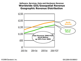 Core-business revenue includes software, hardware, services and data products. The breakdown for these areas for 2004 are as follows:
Software comprised over one-half of total revenue, with revenues from GIS software vendors reaching $1.5 billion. Leading the market in software revenues were Environmental Systems Research Institute, Inc. (ESRI), Bentley and Intergraph Corporation. Together, the three companies accounted for about half of the industry's total software revenues. Other software leaders included Autodesk, Inc., Leica Geosystems, GE Energy, MapInfo, MacDonald Dettwiler, SICAD Geomatics, and LogicaCMG.
Data was the second-largest component of core-business revenues, accounting for quarter of total refenue or $677 million. Sales of commercial data sets are skyrocketing and are projected to continue to grow strongly as consumers and businesses become more aware of and purchase geo-enabled devices.
Services came in third, with core-business vendors accounting for one fifth of total core-business revenues, or $536 million.
Hardware, a declining component of core-business revenues for many years, dropped again, and accounted for just 4% of total core-business revenues, or $113 million.
Utilities and Government Increase Spending
Revenues from the public sector -the two major segments being state and local governments, and federal governments-led market growth and now account for over one-third of total revenue. While federal governments were among the early adopters of GIS technology, recent trends toward devolving more responsibilities to states and localities have spurred those entities to become important consumers of GIS.
Industries in the regulated sector-utilities, telecommunications, transportation and education-once again are the largest consumers of GIS/Geospatial solutions. Utilities contributed almost half of total regulated-sector GIS revenues, while telecommunications companies accounted for a third.
Private sector growth continues to lag, as companies explore the business benefits of these technologies. Of the major industry segments within the private sector, earth resources represents the largest opportunity, accounting for over one-quarter of total private-sector revenue. Also notable is the AEC segment, driven by growing acceptance of geo-capable engineering applications.
In-depth analysis of the structure and composition of the GIS/Geospatial market, a detailed description of Daratech's GIS/Geospatial market model, profiles of major core-business participants and their product lines, and other background information is available onlline in the just-released publication "GIS/Geospatial Markets and Opportunities".
About Daratech
Daratech, Inc. is a leading provider of information technology market research and technology assessment, advisory and strategic consulting services, and executive-level conferences for manufacturing, engineering, construction and plant operations. Established in 1979, Daratech specializes in global GIS/Geospatial, PLM, CAD/CAM, digital product simulation (CAE), PDM/EDM, AECO PLM (architecture, engineering, construction, operations, plant lifecycle management), document/enterprise content management, and related areas.
Core-business revenue includes software, hardware, services and data products. The breakdown for these areas for 2004 are as follows:
Software comprised over one-half of total revenue, with revenues from GIS software vendors reaching $1.5 billion. Leading the market in software revenues were Environmental Systems Research Institute, Inc. (ESRI), Bentley and Intergraph Corporation. Together, the three companies accounted for about half of the industry's total software revenues. Other software leaders included Autodesk, Inc., Leica Geosystems, GE Energy, MapInfo, MacDonald Dettwiler, SICAD Geomatics, and LogicaCMG.
Data was the second-largest component of core-business revenues, accounting for quarter of total refenue or $677 million. Sales of commercial data sets are skyrocketing and are projected to continue to grow strongly as consumers and businesses become more aware of and purchase geo-enabled devices.
Services came in third, with core-business vendors accounting for one fifth of total core-business revenues, or $536 million.
Hardware, a declining component of core-business revenues for many years, dropped again, and accounted for just 4% of total core-business revenues, or $113 million.
Utilities and Government Increase Spending
Revenues from the public sector -the two major segments being state and local governments, and federal governments-led market growth and now account for over one-third of total revenue. While federal governments were among the early adopters of GIS technology, recent trends toward devolving more responsibilities to states and localities have spurred those entities to become important consumers of GIS.
Industries in the regulated sector-utilities, telecommunications, transportation and education-once again are the largest consumers of GIS/Geospatial solutions. Utilities contributed almost half of total regulated-sector GIS revenues, while telecommunications companies accounted for a third.
Private sector growth continues to lag, as companies explore the business benefits of these technologies. Of the major industry segments within the private sector, earth resources represents the largest opportunity, accounting for over one-quarter of total private-sector revenue. Also notable is the AEC segment, driven by growing acceptance of geo-capable engineering applications.
In-depth analysis of the structure and composition of the GIS/Geospatial market, a detailed description of Daratech's GIS/Geospatial market model, profiles of major core-business participants and their product lines, and other background information is available onlline in the just-released publication "GIS/Geospatial Markets and Opportunities".
About Daratech
Daratech, Inc. is a leading provider of information technology market research and technology assessment, advisory and strategic consulting services, and executive-level conferences for manufacturing, engineering, construction and plant operations. Established in 1979, Daratech specializes in global GIS/Geospatial, PLM, CAD/CAM, digital product simulation (CAE), PDM/EDM, AECO PLM (architecture, engineering, construction, operations, plant lifecycle management), document/enterprise content management, and related areas.
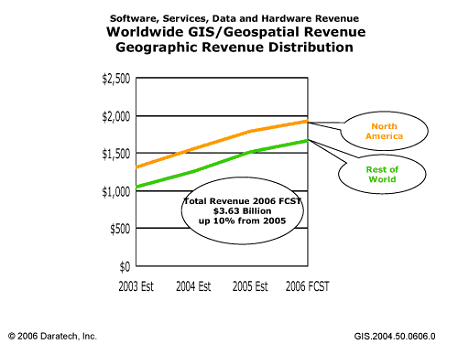 Core-business revenue includes software, hardware, services and data products. The breakdown for these areas for 2004 are as follows:
Software comprised over one-half of total revenue, with revenues from GIS software vendors reaching $1.5 billion. Leading the market in software revenues were Environmental Systems Research Institute, Inc. (ESRI), Bentley and Intergraph Corporation. Together, the three companies accounted for about half of the industry's total software revenues. Other software leaders included Autodesk, Inc., Leica Geosystems, GE Energy, MapInfo, MacDonald Dettwiler, SICAD Geomatics, and LogicaCMG.
Data was the second-largest component of core-business revenues, accounting for quarter of total refenue or $677 million. Sales of commercial data sets are skyrocketing and are projected to continue to grow strongly as consumers and businesses become more aware of and purchase geo-enabled devices.
Services came in third, with core-business vendors accounting for one fifth of total core-business revenues, or $536 million.
Hardware, a declining component of core-business revenues for many years, dropped again, and accounted for just 4% of total core-business revenues, or $113 million.
Utilities and Government Increase Spending
Revenues from the public sector -the two major segments being state and local governments, and federal governments-led market growth and now account for over one-third of total revenue. While federal governments were among the early adopters of GIS technology, recent trends toward devolving more responsibilities to states and localities have spurred those entities to become important consumers of GIS.
Industries in the regulated sector-utilities, telecommunications, transportation and education-once again are the largest consumers of GIS/Geospatial solutions. Utilities contributed almost half of total regulated-sector GIS revenues, while telecommunications companies accounted for a third.
Private sector growth continues to lag, as companies explore the business benefits of these technologies. Of the major industry segments within the private sector, earth resources represents the largest opportunity, accounting for over one-quarter of total private-sector revenue. Also notable is the AEC segment, driven by growing acceptance of geo-capable engineering applications.
In-depth analysis of the structure and composition of the GIS/Geospatial market, a detailed description of Daratech's GIS/Geospatial market model, profiles of major core-business participants and their product lines, and other background information is available onlline in the just-released publication "GIS/Geospatial Markets and Opportunities".
About Daratech
Daratech, Inc. is a leading provider of information technology market research and technology assessment, advisory and strategic consulting services, and executive-level conferences for manufacturing, engineering, construction and plant operations. Established in 1979, Daratech specializes in global GIS/Geospatial, PLM, CAD/CAM, digital product simulation (CAE), PDM/EDM, AECO PLM (architecture, engineering, construction, operations, plant lifecycle management), document/enterprise content management, and related areas.
Core-business revenue includes software, hardware, services and data products. The breakdown for these areas for 2004 are as follows:
Software comprised over one-half of total revenue, with revenues from GIS software vendors reaching $1.5 billion. Leading the market in software revenues were Environmental Systems Research Institute, Inc. (ESRI), Bentley and Intergraph Corporation. Together, the three companies accounted for about half of the industry's total software revenues. Other software leaders included Autodesk, Inc., Leica Geosystems, GE Energy, MapInfo, MacDonald Dettwiler, SICAD Geomatics, and LogicaCMG.
Data was the second-largest component of core-business revenues, accounting for quarter of total refenue or $677 million. Sales of commercial data sets are skyrocketing and are projected to continue to grow strongly as consumers and businesses become more aware of and purchase geo-enabled devices.
Services came in third, with core-business vendors accounting for one fifth of total core-business revenues, or $536 million.
Hardware, a declining component of core-business revenues for many years, dropped again, and accounted for just 4% of total core-business revenues, or $113 million.
Utilities and Government Increase Spending
Revenues from the public sector -the two major segments being state and local governments, and federal governments-led market growth and now account for over one-third of total revenue. While federal governments were among the early adopters of GIS technology, recent trends toward devolving more responsibilities to states and localities have spurred those entities to become important consumers of GIS.
Industries in the regulated sector-utilities, telecommunications, transportation and education-once again are the largest consumers of GIS/Geospatial solutions. Utilities contributed almost half of total regulated-sector GIS revenues, while telecommunications companies accounted for a third.
Private sector growth continues to lag, as companies explore the business benefits of these technologies. Of the major industry segments within the private sector, earth resources represents the largest opportunity, accounting for over one-quarter of total private-sector revenue. Also notable is the AEC segment, driven by growing acceptance of geo-capable engineering applications.
In-depth analysis of the structure and composition of the GIS/Geospatial market, a detailed description of Daratech's GIS/Geospatial market model, profiles of major core-business participants and their product lines, and other background information is available onlline in the just-released publication "GIS/Geospatial Markets and Opportunities".
About Daratech
Daratech, Inc. is a leading provider of information technology market research and technology assessment, advisory and strategic consulting services, and executive-level conferences for manufacturing, engineering, construction and plant operations. Established in 1979, Daratech specializes in global GIS/Geospatial, PLM, CAD/CAM, digital product simulation (CAE), PDM/EDM, AECO PLM (architecture, engineering, construction, operations, plant lifecycle management), document/enterprise content management, and related areas.
Saturday, June 24, 2006
Welcome to the ESRI UC Blog
Welcome to the ESRI User Conference Blog, created to bring the conference experience online. The ESRI User Conference will bring some 15,000 GIS users to San Diego August 7-11 to explore, together, how GIS can better serve organizations and our communities. This is the largest GIS event in the world, and I encourage you to attend if you haven’t already planned to do so.
During the conference week, we will bring you highlights of the many events going on, such as the Plenary Session and Map Gallery. We invite you to submit comments and post entries to share your conference experiences with fellow attendees and others who want to learn more about the conference. To submit a post, send an e-mail to UCblog@esri.com. Or, if you read a blog that interests you, click the comment link at the end of the entry to share your thoughts on the subject.
This exchange of information is what the ESRI community is all about. We move forward together, sharing knowledge, sharing stories, and communicating our world.
Have a great conference.
Sincerely,Jack Dangermond, ESRI President
Monday, June 19, 2006
Strong Angel III: Integrated Disaster Response Demonstration:
"THE SCENARIO
A Complex Contingency: A lethal and highly-contagious virus gradually begins to spread around the globe. Infection rates are high, deaths are frequent, and no vaccine is available. Cities all over the world fall under quarantine. Emergency services and medical centers are stressed and national government agencies, affected just as severely as the cities themselves, cannot provide assistance. And then the situation goes from fragile to brittle. A terrorist cell, having long waited for such an opportunity, launches a wave of successful cyber attacks in a medium size city somewhere in the developed world, bringing down grid power, Internet access, land and cellular telephones. Other, more subtle, attacks follow, and it's difficult to sort out the mess.
If there were ever a time to work effectively together, this would be it.
Recognizing that a comparable scenario might one day unfold in real life, a diverse group of disaster responders, technologists, and community leaders will assemble in San Diego in August of 2006 for an event designed to simulate a truly complex disaster. Over the course of seven days, on the campus of San Diego State University and in the streets of the city, we will explore techniques and technologies for responding effectively when the response itself must adapt to cascading losses. By demonstrating what is possible through public and private-sector partnerships within a community, we intend to develop approaches to cultivating local resilience that may be useful for any city, here or abroad."
Subscribe to:
Posts (Atom)

 Posts
Posts

