This week during the Environmental Systems Research Institute Developer Conference in Palm Springs, CA, ESRI announced their extended partnership with Microsoft’s Virtual Earth business unit granting native access to Virtual Earth’s imagery and road network map data within ArcGIS Desktop and Server. How’s that for a footprint? At the very least it makes the GIS world a bit more interesting, no?
Showing posts with label Press Release. Show all posts
Showing posts with label Press Release. Show all posts
Thursday, March 26, 2009


Friday, February 27, 2009
Map Use, the Quintessential Book on How to Read and Analyze Maps – ESRI Press
New book from ESRI Press.
"Map Use was written for people who want to use maps to better understand not only the physical environment but the human, social, political, and economic environments as well," says A. Jon Kimerling, the book's co-author and interim chairman of the Department of Geosciences at Oregon State University in Corvallis. "This sixth edition takes readers beyond the graphic symbols that comprise maps and into cartographers' decision-making processes to give them the insights they need to better use maps."
Read more about it: http://tinyurl.com/cpqroa
Thursday, February 05, 2009
ArcGIS Server / ArcGIS Mobile Code Challenge
ESRI Offers $16,000 in Cash Prizes for the 2009 ArcGIS Server Mashup and ArcGIS Mobile Code Challenges
Redlands, California—ESRI invites developers to share their creativity and expertise with the geographic information system (GIS) developer community by submitting original code samples to the ArcGIS Server Mashup and ArcGIS Mobile Code Challenges at www.esri.com/codechallenge. The first-place prize for the ArcGIS Server Mashup Code Challenge is US$7,000, and the second-place prize is US$3,000. The first-place prize for the ArcGIS Mobile Code Challenge is US$4,000, and the second-place prize is US$2,000.
The ESRI developer community will have an opportunity to review and vote for the top two entries in each challenge based on creativity, applicability, and the relevance of each code sample. Each entry must be a mobile GIS application developed using the ArcGIS Mobile Software Development Kit (SDK) or a Web mashup built with ArcGIS Server SDKs.
Code challenge winners will be announced at the 2009 ESRI Developer Summit, an event for developers who use GIS, mapping, and spatial data. The summit will be held March 23–26, 2009, in Palm Springs, California. Developers will learn the latest GIS technologies and best practices to build, customize, and deploy spatially enabled applications.
These code challenges are open to developers worldwide, including ESRI business partners, provided the applicant or the applicant's organization is a licensed user of ArcGIS Server 9.2, ArcGIS Server 9.3, or a current ESRI Developer Network (EDN) subscriber.
More info: http://www.esri.com/news/releases/09_1qtr/2009_arcgis_code_challenge.html
Details: http://www.esri.com/codechallenge
Tuesday, December 02, 2008
Getting to Know ArcGIS Desktop – 9.3
Many of you have probably seen – and hopefully used! – this book over the years. It has been very popular and I hear from many folks that it is very useful to them. So it is nice to see that it is being updated for ArcGIS Desktop 9.3!
----------------
ESRI Press Updates Getting to Know ArcGIS Desktop for the 9.3 Software Release

Redlands, California—ESRI Press has published an update to its best-selling book Getting to Know ArcGIS Desktop: Basics of ArcView, ArcEditor, and ArcInfo, Second Edition, with revisions that will make the exercises compatible with the latest software release, ArcGIS 9.3.
Getting to Know ArcGIS Desktop, an ESRI Press best seller for seven years, has schooled tens of thousands of people in the basics of how to use geographic information system (GIS) software technology.
The workbook introduces GIS concepts and capabilities and describes the features and functionality in ArcView, ArcEditor, and ArcInfo, the core products in the ArcGIS Desktop line. Step-by-step exercises, accompanied by richly detailed illustrations, teach basic GIS tasks such as how to conduct spatial analyses, make maps, and build and edit spatial databases.
Readers will learn to use the software applications that form the building blocks of ArcGIS: ArcMap, used for displaying and querying maps, and ArcCatalog, used for managing geographic data. They also will learn how to create a personal geodatabase; geocode addresses; join or relate tables; and build models using ModelBuilder, a graphical interface for diagramming and processing solutions to complex spatial analysis problems.
Instructions in Getting to Know ArcGIS Desktop have been updated to reflect ArcGIS 9.3 enhancements. To learn more about the latest version of ESRI's software, visit www.esri.com/whatsnew. The workbook includes a 180-day single-use trial version of ArcView 9.3 software on DVD and a CD of data for working through the exercises.
Getting to Know ArcGIS Desktop: Basics of ArcView, ArcEditor, and ArcInfo, Second Edition Updated for ArcGIS 9.3 (ISBN: 9781589482104, 600 pages, $79.95), is available at online retailers worldwide, at www.esri.com/esripress, or by calling 1-800-447-9778. Outside the United States, visit www.esri.com/esripressorders for complete ordering options or contact your local ESRI distributor. For a current distributor list, visit www.esri.com/distributors. Interested retailers can contact ESRI Press book distributor Ingram Publisher Services.
Saturday, November 22, 2008
Microsoft & ESRI team to geo-enhance FusionX
Watch for more on this in 2009.
---------------------
November 20, 2008
Microsoft, ESRI to Help Improve Homeland Security Operations
Technology partnership in FusionX makes fusion center situational analysis affordable, easy to use.
Redmond, Washington, and Redlands, California—Microsoft Corp. and ESRI together are driving Homeland Security innovations to more effectively help protect citizens, prevent and solve crimes, and enable counter-terrorism through software. The newly formed collaboration will combine the best capabilities from both organizations in geospatial and collaborative technologies, and will result in advanced intelligence for state and local data fusion centers and emergency operations centers.
An intended product of this collaboration is the FusionX Appliance, a baseline IT architecture for fusion centers, which will provide users with advanced collaboration and geospatial intelligence capabilities by combining the power of ESRI’s ArcGIS Server Advanced Enterprise with the collaboration capabilities of Microsoft Office SharePoint Server 2007.
FusionX will enable homeland security and law enforcement personnel to analyze previously disparate data sets in a mapping context and easily share that information in near real time with relevant stakeholders. FusionX will enhance the abilities of fusion center directors at the strategic and tactical level, enabling them to visualize patterns and trends to help prevent future acts of terrorism and crime, and facilitate a faster and more informed response when necessary. Through the intake of raw data such as fire, police and citizen reports, FusionX will allow for geocoding and mapping of the data to help detect man-made acts of terrorism and crime, such as organized, gang and drug-related activity. Critical GIS data is made accessible and shareable, replacing current collaborative analysis methods that rely on paper exchange and e-mail.
The IT architectural features of the appliance include the following:
- Sophisticated management dashboards through the advanced monitoring, modeling, analysis and planning capabilities of ArcGIS Server and Microsoft Office PerformancePoint Server 2007
- ESRI ArcGIS Server Advanced Enterprise, Microsoft Office SharePoint Server 2007, Microsoft Office PerformancePoint Server 2007, Microsoft SQL Server 2008 and access to terabytes of high-quality pre-rendered base maps and imagery
- An advanced situational awareness portal with support for GeoRSS feeds, Keyhole Markup Language (KML) feeds and other data that will be integrated in the SharePoint environment for access control features and information sharing
- Best practices and foundational content specific to anticipated operator and analyst requirements. Customers will be able to customize the software as necessary, but the goal is to deliver capability that is usable after only minimal configuration.
Our police forces, sheriff departments and fusion center managers are increasingly relying on collaboration tools that help them connect the dots in a world of asymmetrical threats," said Gail Thomas-Flynn, general manager of State and Local Government at Microsoft. "Microsoft and ESRI’s FusionX Appliance provides the layman- to expert-level technology that can facilitate the intake, analysis, visualization and dissemination of information to the right person, at the right time, in the right place."
The FusionX Appliance will deliver advanced geospatial and collaboration capability with minimal configuration and maximum ease of use, yet at an affordable price. It will be extensible so as to grow with the needs of an individual customer. The FusionX Appliance also will allow for the scaling of its technology architecture framework to a broader set of federal, state and local domestic security and public safety agencies with capabilities such as geoprocessing and geoanalytics.
"We understand what it takes to provide secure and mission-critical capabilities in ways that leverage the technologies that many customers already own," said Russ Johnson, public safety industry manager at ESRI. "And that is extremely important in this economic climate."
More information about the program is available at http://www.microsoft.com/industry/government/solutions/FusionX/default.aspx.
# # #
About Microsoft
Founded in 1975, Microsoft (Nasdaq "MSFT") is the worldwide leader in software, services and solutions that help people and businesses realize their full potential.
Press Information:
Matt Donovan, Merritt Group
Tel.: (703) 390-1519
E-mail (press only): donovan@merrittgrp.com
Friday, November 21, 2008
What’s Shakin’?
Golden Guardian took place recently in California. It simulated a big quake as an opportunity for agencies to test their emergency preparedness and also to see if/how they could work together. In San Diego Caltrans District 11 was out with mobile units gathering information of “damaged” roadways and bridges that needed repair or inspection. This field collected data was transmitted up to Sacramento and loaded up into ArcGIS Server based webservices along with data from other agencies around the state. San Diego County EOC was one such agency.
Cities and counties were then able to consume these webservices in their own applications, in Common Operating Picture viewers based on the ArcGIS Server flex API, or in ArcGIS Explorer.
When the fires started breaking out in southern California (Freeway, Sayre, and Tea) before the exercise was complete, they re-tasked servers, loaded in real emergency information gathered at the fires and kept on serving it up to end users fighting the fires and making decisions on how to allocate resources.
-------------------------------------
November 17, 2008
GIS Delivers during the Largest Earthquake Drill in U.S. History
ESRI Provides Staff and Resources for the Great Southern California ShakeOut
Images for Publication

A GIS-based common operating picture provides continuous data updates. Understanding hospital occupancy levels helps officials direct emergency medical service crews transporting new patients.
Redlands, California—At 10:00 a.m. on November 13, 2008, millions of people throughout Southern California participated in the Great Southern California ShakeOut Drill, the largest earthquake preparedness exercise in U.S. history. The drill simulated a magnitude 7.8 earthquake along the San Andreas Fault in Southern California. ESRI supported participating agencies with software, staffing, and resources used during the exercise, which modeled assessment, rescue, relief, and recovery efforts. Geographic information system (GIS) technology was used to help build an accurate, continuously updated emergency information repository; aided decision support and resource management; and enhanced multijurisdictional communication.
"We worked diligently to create a realistic exercise that helps us see where we are with our response capability in the event of a major earthquake," says John Ellison, agency technology officer and geographic information officer (GIO)/California Environmental Resources Evaluation System (CERES) director, California Resources Agency. "By upgrading to ArcGIS Server 9.3 and ArcGIS API for Flex, we have an easy-to-use Web-based viewer suitable for this purpose. We are very pleased with our GIS experience including during the exercise."
The ShakeOut kick-started a weeklong collection of exercises called the Golden Guardian 2008, held November 13–18 and involving 5,000 participants from public agencies around the state. Based on scientists' predictions of what would occur during and after a major earthquake, the simulated results included 1,800 dead, 50,000 injured, and $200 billion in damages. The goal of the drill was to test and evaluate processes, equipment, technologies, and shared workflows. Results helped determine best practices, opportunities for improvement, and potential new capabilities.
"The GIS platform developed for the Golden Guardian 2008 exercise proved to be an invaluable tool," says Paul Hardwick, GIS project manager, San Diego Homeland Security Regional Technology Center. "We were able to post pertinent information to provide situational awareness to the state emergency command center and affected communities as well as areas adjacent to the disaster. The ability to transfer information between systems and to implement server-based tasks for analysis helped make the event a success."
Multiple Emergency Operations Centers (EOCs), including California Resources Agency, deployed ESRI's Situational Awareness Bundle for the ShakeOut. The bundle provides a complete framework for geospatial intelligence analysis, visualization, and management. Users managed multiple events with the bundle's ready-to-operate hardware solution, its powerful data fusion and analysis engine, and a set of fully customizable viewers to display the affected areas. Staff also used terabytes of prerendered data including street networks, raster imagery, topographic maps, shaded relief imagery, and elevation data.
GIS helped collect and manage large volumes of diverse data including simulated damaged buildings, roads, and power and water infrastructure; affected populations; delivered supplies; and the deployment of fire, emergency medical services, law enforcement, and homeland security staff. Live data, such as weather updates, video, and Global Positioning System (GPS) information, was streamed into the GIS database and disseminated to individuals using desktop computers, mobile devices, and Web-enabled laptops. Mobile GIS helped field crews collect remotely sensed data that was automatically sent back to the comprehensive spatial database.
The ShakeOut was organized by the Earthquake Country Alliance (ECA), a partnership of earthquake professionals, emergency responders, business leaders, and community activists. The group has been planning the ShakeOut since 2006.
Flex API for ArcGIS Server
The folks I’ve shown sample Flex viewer sites have really liked what they saw. I think these will be a popular item for a lot of users.
-----------------------
October 29, 2008
New ESRI ArcGIS API for Flex Enhances Web Mapping
Web GIS Tool Gives Developers Direct Access to ArcGIS Server 9.3
Redlands, California—Web geographic information system (GIS) technology takes a forward leap with the release of ESRI's ArcGIS API for Flex. With the Flex API, developers can combine GIS-based Web services from ArcGIS Server with other Web content, which can be displayed in simple, dynamic mapping applications over the Web or on the desktop.
The API exploits the powerful geospatial capabilities of ArcGIS services. Users can transform their local data into a visually rich interactive map, query and display GIS data features and attributes, locate addresses, identify features, and perform complex spatial analytics. Integrated with Adobe Flex Builder 3, Flex is a client-side technology that is rendered by Flash Player 9 or Adobe AIR. As long as developers have access to ArcGIS Server via a URL, they can program with ArcGIS API for Flex remotely. Since the API is built on the Adobe Flex framework, developers can put all Flex components, such as list boxes, data grids, landscapes, and text controls, into custom applications.
Developers can download the API library at the ArcGIS API for Flex Resource Center and access the source code for a variety of samples of displaying tiled maps, turning layers off and on, and switching between different kinds of maps and imagery. The samples demonstrate how to incorporate symbology, create a map layer, geocode, analyze data, add drawing tools, and much more.
The resource center contains specific documentation about using the packages and classes included in the library. The resource center also includes a code gallery with sample applications for the developer community to see each other's work and speed learning.
A podcast is available that features Mansour Raad, a senior software architect at ESRI, discussing the new ArcGIS Server API for Flex. It includes topics such as MXML, ActionScript, REST, and Adobe AIR.
An early adopter of ArcGIS API for Flex and ArcGIS Server is the City of Boston, Massachusetts, which recently deployed the Solar Boston application, a public-facing Web mapping application designed to showcase active renewable energy installations. The application with a fast and visually dynamic user interface allows users to calculate the solar power that can potentially be obtained via rooftops.
"We chose ArcGIS API for Flex because it allowed us to leverage the power of ArcGIS Server while delivering a rich, interactive experience to our users," explains Greg Knight, senior GIS applications developer, Boston Redevelopment Authority. "Development was both fast and enjoyable, and we are pleased with the functionality and performance of the application."
To learn more about the ArcGIS API for Flex and ArcGIS Server, visit www.esri.com/flex or call 1-800-447-9778.
Friday, September 19, 2008
GIS Saves Baltimore County $4 Million Annually - Government Technology
Aug 20, 2008, By Matt Freeman
Found in: Geospatial
Baltimore County, Md., operates an enterprise GIS that is available to all county agencies and departments. The county also gives the public access to its GIS maps, data and services through a fee-based program that's designed to provide printed copies of published maps and access to the digital data and services for the creation of custom products based on customer specifications.
While GIS is used extensively by most county departments and is popular with the public, it comes with a hefty price tag. The county's budget for GIS hardware, software, personnel, database maintenance and training has steadily risen since purchasing its first ESRI ArcInfo license back in the mid-1980s. As a result, the Office of Information Technology (OIT) and Office of Budget and Finance initiated a strategic business plan focusing on determining the return on investment and use of Baltimore County's GIS.
The county contracted with Dewberry, a geospatial technology firm, to conduct the study. Rather than examining the historical costs and benefits of the county's GIS technology utilization, the study was accomplished during an eight-month period from September 2006 through May 2007. A thorough analysis of Dewberry's findings were outlined and published in the Baltimore County GIS Strategic Business Plan.
In the plan, Dewberry provides detailed information on existing GIS layers; identifies key users and their uses; establishes current benefits, including cost avoidance, revenue and productivity gains; distinguishes current costs, including software, hardware, support and maintenance; and delivers recommendations on key areas the county could focus on for future GIS use. ...For more information and stats, follow link below...
GIS Saves Baltimore County $4 Million Annually - Government Technology
Friday, August 15, 2008
ESRI UC Blog : Governor O’Malley Fights Back with GIS
Governor O’Malley Fights Back with GIS
One of the biggest fans of GIS on the East Coast is undoubtedly Martin O'Malley.
As mayor of Baltimore and now the governor of Maryland, he spearheaded the use of geospatial technology to help measure government performance whether in fighting crime, filling potholes, or reducing water pollution.
O'Malley told the story of the powerful nature of GIS from his perspective when he spoke Sunday at the 2008 ESRI Senior Executive Seminar in San Diego. Top-level executives from around the world attended the seminar, which preceded the start of the ESRI UC. The executives gathered to learn how GIS is being successfully implemented at major corporations, in government, and non-governmental organizations.
O'Malley said when he took the reins as mayor of Baltimore in 1999, he inherited some serious challenges: a high crime rate, a plummeting population, and therefore a loss of tax revenue to tackle the problems.
"This left us a legacy of underperforming schools, underperforming and unresponsive city services, littered streets and alleys-thousands of vacant buildings and vacant hearts," he said.
To revive the city...read the rest of the story - follow the link below...
Sunday, August 10, 2008
Web site helps police,neighbors stay informed | The San Diego Union-Tribune
[ What's missing from this site? A few things. A map might be nice to show where things are happening, but what would really be useful in my mind is the result of map analysis - which is what I thought this was going to be when I saw the headline - like the City of San Diego has (and which has a very similar name - Neighborhood eWatch - but has been available for years). For more info on the San Diego version go here: http://apps.sandiego.gov/ewatch/index.jsp ) What the San Diego version does is take any address within the city that you provide, geocode it, buffer the result and overlay that on the types of crimes you select - and emails you a report each day so you can see how nice or rotten the neighborhood is.
I do have to say that, after reading a few of the blog postings, it looks like some El Cajon Police Officers are regulars on the blog and are returning posts and doing something about what the citizens are posting about - so that is fantastic! ]
Web site helps police,neighbors stay informed
August 9, 2008
EL CAJON: Neighborhood Watch is going digital in El Cajon, where police have launched an interactive Web page to encourage residents to blog and share community concerns with each other and police.
The Web page, elcajonneighbors.org, debuted in May and has already sparked conversation among residents and proved a resource for police officers, some of whom check the site regularly for tips.
“It's another tool for us to use to interact with the community,” said El Cajon police Officer Dan Hansen, a crime prevention specialist who came up with the idea for the site.
At El Cajon Neighbors, people can sign up for e-mail alerts, find out who their school resource officers are and learn about Neighborhood Watch and other crime-fighting programs. The centerpiece is the Neighborhood Blog, where people can post information about community nuisances and potential crimes, such as problems with homeless encampments, speeding on residential streets and barking dogs.
“There is a lot of information out there, a lot of information exchanged (on the Internet) and really, we should be capitalizing on that,” said El Cajon police Lt. Jeff Davis.
The department has even started its own internal blog where patrol officers can communicate with each other about issues on their beats. Officers who work the day shift, for example, rarely see the officers on the night shift.
“It's easier than leaving written notes,” Davis said, “and it's in real time.”
The Web site is part of a larger initiative to reach out to residents and business owners, some of whom might be reluctant to call police about problems that don't rise to the level of a dangerous crime.
“As long as they're not demeaning or insulting to anybody, they can blog about anything in the neighborhood,” Hansen said. “The thing that surprises me the most is how many people have taken to it.”
El Cajon Neighbors has logged more than 28,000 hits since its inception, said Hansen, who plans to add short crime prevention videos to the site. He is trying to spread the word about the site through residents who are working with police to re-energize Neighborhood Watch.

Web site helps police,neighbors stay informed | The San Diego Union-Tribune
Wednesday, June 04, 2008
City of Dover, Delaware, Deploys Groundbreaking GIS Application for NASCAR Events
ArcWatch, May 2008
ArcGIS Server and ArcGIS Mobile Help Officials Monitor Events and Respond Faster to Emergencies
City of Dover, Delaware, Deploys Groundbreaking GIS Application for NASCAR Events
By Jesse Theodore, ESRI Writer

NASCAR fans gather for the races at the Dover International Speedway in Dover, Delaware. Photograph by Reinhold Matay.The weekend of May 30–June 1, more than 140,000 fans will line "The Monster Mile" in Dover, Delaware, to whistle and cheer as they urge on their favorite drivers during three days of NASCAR races.
But while others focus on cars traveling at speeds up to 150 miles per hour around the track at Dover International Speedway, public safety officials will be busy watching for problems and ensuring a safe, secure event. And as medical emergencies, disturbances, and code violations are reported, officials will rely on geographic information system (GIS) technology to help them respond to, manage, and coordinate activities faster than ever before.
Managing a City of Race Fans
One of the toughest tasks for local government agencies is managing large-scale events. The City of Dover (population 35,000) has a particularly unusual public safety issue. Twice a year, the city hosts major NASCAR races. The city's population swells to more than 200,000 as fans from all over the United States descend on Dover.
This creates an enormous challenge as local government officials work to protect the many temporary residents visiting the area. Staff and resources come from the fire, health, emergency medical services, law enforcement, public works, and utilities departments and agencies.

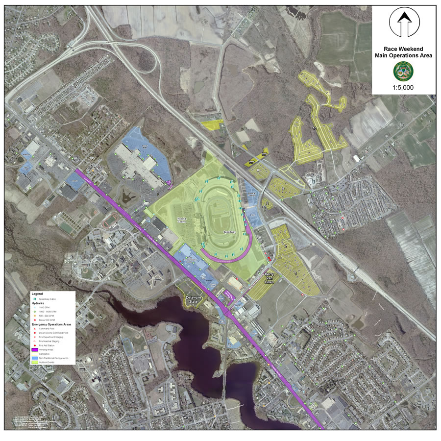
A map of the overall operational area with a 2007 aerial photograph.To help coordinate every aspect of this vast operation, the City of Dover recently deployed an advanced enterprise GIS platform that gives venue managers the ability to access data and visualize what's happening where at Dover International Speedway. GIS also lets them capture, integrate, and analyze important public safety data, which helps them respond faster and more efficiently to emergencies or other problems. The enterprise solution was successfully used during the NASCAR races that the speedway hosted in June and September 2007.
GIS technology allows event managers, stationed in the Kent County, Delaware, mobile command center next door to the speedway, to view digital map displays of the entire race venue including the track. On the digital maps, the managers receive information concerning incidents and crowd activity.
Using ArcGIS Server and ArcGIS Mobile software from ESRI, staff operating in the command center and in the field can visualize where disturbances, code violations, accidents, and other incidents occur.

Read the full article: ESRI ArcWatch May 2008 - City of Dover, Delaware, Deploys Groundbreaking GIS Application for NASCAR Events
Tuesday, March 11, 2008
Press Release -- New Technical Support Director Joins ESRI Staff
New Technical Support Director Joins ESRI Staff
Redlands, California—ESRI recently welcomed Michael Kim to head its Technical Support Division. Kim comes to ESRI as a customer relationship management (CRM) and contact center senior executive with more than 15 years' experience servicing Fortune 100 clients in the United States and Asia-Pacific. He has proven executive-level experience implementing the design of enterprise-level CRM and contact center infrastructures in global organizations. Kim's responsibilities as technical support director include management of support services operations with the goal of maintaining and growing ESRI's world-class customer service.
Kim is a recognized leader in the contact center management field as well as a member of the Genesys Executive Global CTI Advisory Board. His accomplishments in the industry have been covered internationally and documented by major media groups including CIO Magazine, E-week, and BNI Media Group. In CIO Magazine, Kim was recognized as one of the top 50 technologists of the decade. He has also personally launched and delivered CRM and contact center solutions for some of the largest global software releases in the world at Microsoft, Priceline.com, and Samsung Corporation.
"My professional goal is to create the best possible infrastructure to make the most out of each customer contact," says Kim. "ESRI's strong international presence and reputation for quality technical support both domestically and abroad is the perfect platform from which to do that."
Says ESRI president Jack Dangermond, "We are pleased to welcome Michael Kim to the ESRI family. Kim's wide experience and visionary drive for technical innovation in contact center management made him the obvious choice to lead our Technical Support Division."
Press Release -- New Technical Support Director Joins ESRI Staff
Wednesday, March 05, 2008
Press Release -- ESRI Opens Office in California State Capital
Redlands, California—Geographic information system (GIS) industry leader ESRI officially opened the doors to its Sacramento, California, satellite office on January 15, 2008. The new location will allow ESRI to better support its users in central and northern California and Nevada and will provide a convenient site for agencies, to spend time learning how to leverage GIS.
"As ESRI and the GIS community grow, the Sacramento satellite office gives us the ability to better connect with our users in the region and provide GIS training, support, and services," says Nate Johnson, ESRI regional manager for California, Nevada, and Hawaii. "Its location near the state capitol will provide government and private agencies using ESRI software with the opportunity to work in close proximity with our GIS experts. Our new training lab will offer ESRI's complete curriculum of instructor-led classes, and the new enterprise lab will provide a place for GIS knowledge to be shared among different user groups."
Sacramento joins several other major U.S. cities such as Washington, D.C.; Boston; Minneapolis; and Denver with ESRI office locations where staff and GIS software users can attend technical workshops and seminars, host meetings and project briefings, and participate in additional ESRI-authorized training.
Adds ESRI president Jack Dangermond, "GIS provides a geographic approach to doing business. Its ability to share, store, and visualize information gives utility companies; private industry; and federal, state, and local governments the power to streamline workflows, improve decision making, reduce costs, and better model and communicate strategies. We believe that the Sacramento satellite office will help ESRI serve its users in the area to ensure that their businesses remain productive, effective, and profitable."
The ESRI Sacramento satellite office is located at 1600 K Street, Suite 4C, Sacramento, CA 95814 tel.; 916-448-2412; fax: 909-307-3025.
Press Release -- ESRI Opens Office in California State Capital
Press Release -- ESRI Recognizes San Diego County Officials for GIS Work during Wildfires
ESRI Recognizes San Diego County Officials for GIS Work during Wildfires
GIS Use Improved Communications, Saved Infrastructure, and Assisted in Evacuations
Redlands, California—San Diego County officials were recently recognized for their work using geographic information system (GIS) software behind the scenes during recent wildfires that consumed tens of thousands of acres in Southern California this past fall. ESRI, the world's leading GIS software company, presented Paul Hardwick, GIS unit leader, Office of Emergency Services, with the Making a Difference Award at the ESRI California Regional User Group Meeting held in Sacramento, California, last month. This award is given to people and organizations that use GIS in exceptional ways.
During the 2007 fires, Hardwick and his team used ESRI software to manage a wide range of data and create maps that were critical for directing strategic operations. "Paul's team epitomizes ESRI's vision of how people can use technology to more effectively and responsively run their organizations," says Jack Dangermond, president, ESRI. "They are using it to serve the community in the best ways possible. Their efforts during the San Diego fires were exemplary; lives and property were saved because they had the foresight to apply their past experiences to this crisis, making a significant impact on the outcome of the fires."
GIS is a computer software technology that links geography to information, giving users a much clearer picture of data and allowing many types of analysis to be done. During the fires, this technology helped officials monitor fire activities and share essential information among response agencies and with the public. "With five major fires burning throughout the county, the timely and detailed maps our GIS team was able to produce were critical in our ability to not only coordinate our emergency responders but also provide critical information to the public," says Ron Lane, director of the San Diego County Office of Emergency Services. "The GIS maps we provided to the media and on our Web site were instrumental in helping citizens make the life-or-death decision of whether to evacuate."
"It was rewarding to see ArcGIS being used in real time to aid in the decision-making process throughout this emergency including in the policy room at the Emergency Operations Center," says Tim Craig, ESRI account executive for the San Diego area. "The county's work on a standard operating procedure [SOP] in the wake of the 2003 wildfires led to the efficient use of resources at all levels, from staffing and data capture to analysis and even to plotter paper. The maps being produced showed what was happening in the entire region and served as useful public notification tools. They were ready this time, and it showed in their well-coordinated response effort."
Communication among departments and organizations was much improved with the county's GIS, since the software integrates different information technology systems by ensuring the data is consistent. "GIS-based predictive modeling and mapping led to the evacuation of 2,100 medically fragile, special-needs individuals as well as the containment and removal of hazardous waste before the fire became a danger," says Hardwick. "Using GIS helped us communicate in a more timely and accurate fashion to both the public and other agencies. GIS was instrumental in forming a common understanding of events between all parties involved."
Evacuating people from their homes is not a simple or inexpensive task; using the county's GIS, which combined evacuation data with county demographic data, helped decision makers better understand the true number of people evacuated—an overwhelming 515,000—and their underlying characteristics. "The county developed reentry and recovery plans and assessed the impact of the fires in a remarkable way," says Nate Johnson, manager, California-Hawaii-Nevada region, ESRI. "GIS map images allowed county staff to assess damage to property, assets, and habitat even while the wildfires were still burning. Using a geographic approach to forecast the effects from the fires made it easier to see how best to prioritize efforts in the aftermath of the disaster. Maps provided immediate and vital information such as flood risk, habitat loss, and burned structures. This information proved essential for developing the course for post disaster efforts."
Press Release -- ESRI Recognizes San Diego County Officials for GIS Work during Wildfires
Press Release -- ESRI Received "Strong Positive" Rating in Leading Analyst Firm's MarketScope for Public Safety Geographic Information S
ESRI Received "Strong Positive" Rating in Leading Analyst Firm's MarketScope for Public Safety Geographic Information Systems
Redlands, California—ESRI received a Strong Positive rating, the highest possible, from Gartner, Inc., the leading provider of research and analysis on the global information technology industry. ESRI received this rating in the report entitled MarketScope for Public Safety Geographic Information Systems, 2H07 by Bradley Williams and Jeff Vining and published October 31, 2007. Gartner considers companies receiving a Strong Positive rating to be "providers of strategic products, services or solutions" and recommends that existing customers "continue investments" while potential customers "consider the vendor a strong strategic choice."
Gartner states in the report, "By the end of 2009, 90% of all state and local government public safety organizations in North America will either use or be supported by geographic information systems. Moreover, GIS [geographic information system] technology is becoming a foundation for data management to drive other core applications through interfaces and links to such things as independent devices, including mobile devices, spatial planning and the Internet. As a result, the purpose of this MarketScope is to better understand what GIS providers are currently offering public safety organizations in order to give our clients a better understanding, because many GIS providers produce general-purpose software and then sell it to various vertical markets."
As populations and building development increase, the responsibilities of public safety agencies become more demanding and complex. At the same time, agencies are being called upon to deliver services with greater efficiency and economy.
Organizations' data, including files from legacy systems, can be stored in a GIS geodatabase and used to visualize spatial relationships, revealing trends critical to public safety response and planning.
Solutions from ESRI, including the ArcGIS family of products, enable users to employ one platform to provide a common operating picture for public safety agencies. This platform can be deployed to desktop, mobile, or Web-based clients.
"ESRI’s range of products and commitment to interoperability are proven standards for public safety departments in local and national governments," states Russ Johnson, public safety solutions manager, ESRI. "ESRI technology gives public safety personnel the capability to access and analyze spatial data to support critical decision making quickly when and where it’s needed."
Information and maps can be shared quickly and easily across networks and the Internet using ESRI technology. This maximizes coordination efforts and resources among agencies, giving public safety personnel the ability to manage and analyze large amounts of location-based information. For more information on ESRI’s solutions for public safety, visit http://www.esri.com/publicsafety.
Press Release -- ESRI Software Gives Residential Real Estate Agents and Brokers a Better Look at Houses
ESRI Software Gives Residential Real Estate Agents and Brokers a Better Look at Houses
RouteMAP IMS Provides YourMLSsearch.com with an Affordable, Robust Solution for Hosting Property Information for Multiple Listing Services
Redlands, California—YourMLSsearch.com has integrated ESRI's RouteMAP IMS into its Web hosting services for multiple listing service (MLS) agencies throughout the United States. YourMLSsearch.com provides Internet solutions for real estate agents and brokers including Internet data exchange (IDX), Web site hosting, and Web site development. RouteMAP IMS is incorporated into YourMLSsearch.com's iMapRES, allowing the company to host interactive mapping and residential data searches for more than 80 MLSs in 20 states.
"RouteMAP IMS was the ideal solution for providing this service at a great price to our customers," says Alain Nisam, chief operating officer, YourMLSsearch.com. "We looked at other solutions to power iMapRES and found RouteMAP IMS to be the best choice, since it resides on in-house servers and provides a robust API to create the right look and feel for our clients' Web sites. We are also able to create millions of listings from coordinate data instead of relying on street addresses, unlike any other software in this venue. This allows us to give our customers bulk real estate lookups, saving them the time and cost of frequent updates."
YourMLSsearch.com also finds the data, such as points of interest, bundled with the software to be advantageous in the marketplace. "When you look for a house, you want to know about the neighborhood, for example, what churches, restaurants, and banks are in the area," says Nisam. "We can rely on the data that comes with RouteMAP to give a clear picture of surrounding areas."
RouteMAP IMS data options allow YourMLSsearch.com to provide complete mapping, driving directions, and location information for the United States. Data for North America is provided with the software including Tele Atlas' Dynamap Transportation covering the United States, Canada, and Puerto Rico. North American datasets support street-level routing as well as geocoding by address, postal code, and latitude-longitude.
"We are pleased to be able to offer the solution YourMLSsearch.com was looking for," says Jay Hoffman, RouteMAP IMS product manager, ESRI. "By using this software, the company can provide all the information it needs, including mapping data, to others for the cost of the application instead of by subscription. This means YourMLSsearch.com and its clients can budget effectively year after year and know exactly what their costs will be."
Clients including Sky Sotheby's International Realty use the RouteMAP IMS service provided by YourMLSsearch.com.
Press Release -- Florida Property Appraiser Speeds Valuation Process with ESRI ArcGIS Server
Florida Property Appraiser Speeds Valuation Process with ESRI ArcGIS Server
Web-Based GIS Delivers Geoprocessing Services and Property Information Online
Redlands, California–Retrieving property information in Orange County, Florida, is more convenient than ever thanks to a new Web site based on ArcGIS Server. The Orange County Property Appraiser (OCPA) created an interactive map tool that allows residents, realtors, investors, and anyone who needs Orange County parcel information to get the data they need via an easy-to-use interface. With it, users can search by owner, parcel number, street intersections, and coordinates in addition to generating buffer/mailing lists and creating comparable sales reports. The Web site was designed to meet the needs of today’s high-speed users by quickly delivering the information they need.
OCPA is responsible for determining the value of real estate and tangible personal property in Orange County for the purpose of ad valorem taxation and land records management. Prior to creating the ArcGIS Server Web site, OCPA used ArcIMS to deliver cadastral information online. Although a success, with upwards of 5,000 unique visitors a day, the site required five spatial servers and an application server to manage it. With ArcGIS Server, both the data and application can reside on just one server thanks to the image-caching functionality of ArcGIS Server. ArcGIS Server technology’s multilevel map caching ability makes it possible to display detailed maps with complex rendering in an environment where data needs to be displayed fast. In addition, ArcGIS Server has much improved scalability to accommodate a growing number of users.
Obtaining parcel information is integral to the work of the fire, insurance, and real-estate sectors in our economy. Realtors, land surveyors, insurance companies, mortgage companies, real-estate attorneys, and departments tasked with zoning and permitting all use the online mapping tool on a regular basis. The site gets visitors from about 60 different countries, although the bulk of visitors are from Florida, followed by New York.
Because of the demand from so many professions, OCPA needed technology that could meet the needs of its wide range of customers. The improved rendering ability of ArcGIS Server makes the site better equipped to handle the increased volume of visitors. The Web site allows advanced searches of the property database through multiple user-selected parameters. Advanced searches can be made using criteria specific to residential, commercial, and vacant land properties. Sales analysis of properties using parameters such as use code, year built, and square footage can pinpoint comparative sales. Properties can even be searched for specific site amenities such as lake frontage. Users can simply click on the Orange County map and instantly zoom to an area of interest, or they can select by parcel ID, name, address, or tax account number fields. In response to a query, the coordinates for the appropriate area are retrieved and graphically displayed in the mapping frame, along with a street-level photo of the property and attribute data.
"ArcGIS was a natural progression from ArcIMS because of the caching ability," says Manish Bhatt, IT director for OCPA. "ArcGIS Server’s ability to display precached images was perfect for our needs because of the speed we require to handle the large volume of visitors to the site. The rendering capabilities are lightning fast, which translates to improved customer service." The upgrade was also useful to OCPA because it was in line with its goal of .NET standardization.
For more information, visit the OCPA Map Inquiry System at www.ocpafl.org/disclaimer_map.html.
Press Release -- Florida Property Appraiser Speeds Valuation Process with ESRI ArcGIS Server
Tuesday, March 04, 2008
Press Release -- ESRI Shows SQL Server 2008 Spatial Support at Microsoft Launch
ESRI Shows SQL Server 2008 Spatial Support at Microsoft Launch
ArcGIS 9.3 to Fully Support New Data Types
Redlands, California—ESRI, the leader in geographic information system (GIS) technology, announces its participation in the launch of Microsoft SQL Server 2008, beginning with Microsoft's premier launch event in Los Angeles, California, on February 27. ESRI was the only business partner to demonstrate integration with SQL Server 2008 on stage with Microsoft presenters. This support is the result of a close, multiyear collaboration between ESRI and Microsoft in the development of SQL spatial extensions to SQL Server 2008.
During the Microsoft event, ESRI demonstrated ArcGIS software working in concert with Microsoft SQL Server 2008 to perform business site selection analysis. ESRI will continue to participate in Microsoft SQL Server 2008 launch events throughout the United States.
"ESRI is taking full advantage of SQL Server 2008 to help our government, utilities, and commercial enterprise customers take the geographic approach to improving their business processes," says ESRI president Jack Dangermond. "ESRI and Microsoft together provide the platform to organize and manage geographic information, leading to improved methods for analyzing and using information more effectively to make better decisions."
ESRI offers a complete suite of geospatial software solutions that can operate as clients to SQL Server 2008. The combination of ESRI's extensive geodata management capabilities and SQL Server 2008 will provide customers with the tools they need to seamlessly consume, use, and extend location-based analysis for enterprise-scale computing and Web collaboration.
ESRI's ArcGIS 9.3 software, the next scheduled release of ESRI's ArcGIS suite, will take full advantage of the new spatial technology in the upcoming release of SQL Server 2008. Microsoft will introduce two spatial types: Geography and Geometry.
Read more:
Press Release -- ESRI Shows SQL Server 2008 Spatial Support at Microsoft Launch
Subscribe to:
Posts (Atom)

 Posts
Posts

